Catende geodata
Catende (Pernambuco) is a populated place; located in Brazil in America/Recife (GMT-3) time zone. With population of 23,322 people, there are 823 cities with bigger population in this country. Compared to other cities in Brazil, 72.5% of cities are located further ↓South; 94.4% of cities are located further ←West and 64.3% of cities have higher elevation than Catende. Note1


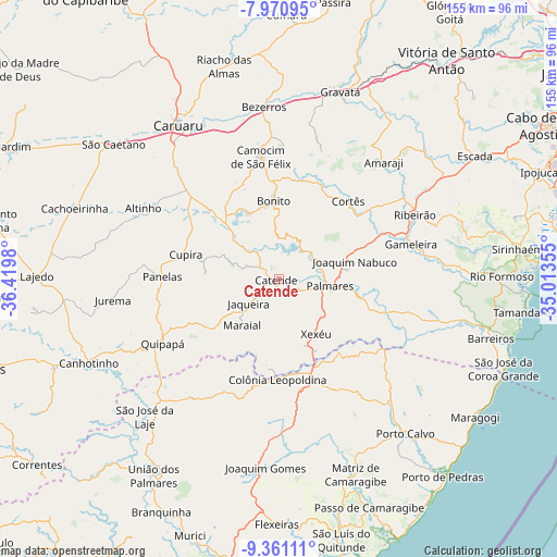
Catende GPS coordinates[2]
8° 40' 0.012" South, 35° 43' 0.012" West
| Map corner | latitude | longitude |
|---|---|---|
| Upper-left | -7.97095°, | -36.4198° |
| Center: | -8.66667°, | -35.71667° |
| Lower-right: | -9.36111°, | -35.01355° |
| Map W x H: | 154.6×154.6 km | = 96.1×96.1mi |
| max Lat: | 2.81972° ⇑27.5% North |
| Catende: | -8.66667° |
| min Lat: | ⇓72.5% South -33.69111° |
| min Long | Catende | max Long |
| -72.89583° | -35.71667° | -32.41083° |
| W 94.4%⇐ | ⇒5.6% E |
Elevation
Elevation of Catende is 172 m = 564 ft, and this is 208.9 m = 685 ft below average elevation for this country.
| Max E: |
1603 m = 5259 ft | 64.3% |
| Avg. | 380.9 m = 1250 ft | |
| Catende | 172 m = 564 ft | |
Min E: |
0 m = 0 ft | 35.7% |
See also: Brazil elevation on elevation.city.
Geographical zone
Catende is located in South Torrid zone (between Equator and Tropic of Capricorn). Distance of Equator is 963.6 km =598.8 mi to North.| Distance of | km | miles | from Catende |
|---|---|---|---|
| Equator | 963.6 | 598.8 | to North |
| Tropic Capricorn | 1642.3 | 1020.5 | to South |
| Antarctic Circle | 6437.5 | 4000.1 | to South |
| South Pole | 9043.4 | 5619.3 | to South |


Nearby cities:
15 places around Catende: (largest is in red/bold)
• Agrestina
34.2 km =21.3 mi,  312°
312°
• Bonito
21.9 km =13.6 mi,  356°
356°
• Camocim de São Félix
34.6 km =21.5 mi,  351°
351°
• Colônia Leopoldina
26.9 km =16.7 mi,  181°
181°
• Cupira
26.2 km =16.3 mi,  282°
282°
• Gameleira
37.4 km =23.2 mi,  75°
75°
• Guabiraba
28.3 km =17.6 mi,  11°
11°
• Joaquim Nabuco
20.7 km =12.9 mi, 76°
• Jundiá
33.7 km =20.9 mi,  152°
152°
• Maraial
16.4 km =10.2 mi,  218°
218°
• Novo Lino
28.7 km =17.8 mi,  164°
164°
• Palmares
13.9 km =8.6 mi,  97°
97°
• Quipapá
37 km =23 mi,  241°
241°
• São Joaquim do Monte
27.8 km =17.3 mi,  339°
339°
• Água Preta
21 km =13 mi, 102°
Sources, notices
• [Note1] Compared only with cities in Brazil existing in our database
• [Src1] Map data: © OpenStreetMap contributors (CC-BY-SA)
• [Src2] Other city data from geonames.org with taken over terms of usage.
• [Src3] Geographical zone / Annual Mean Temperature by Robert A. Rohde @ Wikipedia
