Água Preta geodata
Água Preta (Pernambuco) is a populated place; located in Brazil in America/Recife (GMT-3) time zone. With population of 16,444 people, there are 1125 cities with bigger population in this country. Compared to other cities in Brazil, 72.3% of cities are located further ↓South; 95.9% of cities are located further ←West and 68.8% of cities have higher elevation than Água Preta. Note1


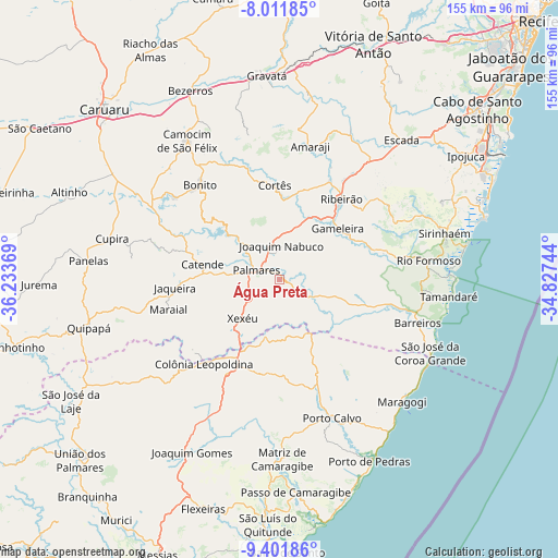
Água Preta GPS coordinates[2]
8° 42' 27" South, 35° 31' 50.016" West
| Map corner | latitude | longitude |
|---|---|---|
| Upper-left | -8.01185°, | -36.23369° |
| Center: | -8.7075°, | -35.53056° |
| Lower-right: | -9.40186°, | -34.82744° |
| Map W x H: | 154.6×154.6 km | = 96.1×96.1mi |
| max Lat: | 2.81972° ⇑27.7% North |
| Água Preta: | -8.7075° |
| min Lat: | ⇓72.3% South -33.69111° |
| min Long | Água Preta | max Long |
| -72.89583° | -35.53056° | -32.41083° |
| W 95.9%⇐ | ⇒4.1% E |
Elevation
Elevation of Água Preta is 133 m = 436 ft, and this is 247.9 m = 813 ft below average elevation for this country.
| Max E: |
1603 m = 5259 ft | 68.8% |
| Avg. | 380.9 m = 1250 ft | |
| Água Preta | 133 m = 436 ft | |
Min E: |
0 m = 0 ft | 31.2% |
See also: Brazil elevation on elevation.city.
Geographical zone
Água Preta is located in South Torrid zone (between Equator and Tropic of Capricorn). Distance of Equator is 968.2 km =601.6 mi to North.| Distance of | km | miles | from Água Preta |
|---|---|---|---|
| Equator | 968.2 | 601.6 | to North |
| Tropic Capricorn | 1637.7 | 1017.6 | to South |
| Antarctic Circle | 6433 | 3997.3 | to South |
| South Pole | 9038.9 | 5616.5 | to South |


Nearby cities:
15 places around Água Preta: (largest is in red/bold)
• Amaraji
37.1 km =23.1 mi,  13°
13°
• Barreiros
39.8 km =24.7 mi,  108°
108°
• Bonito
34.2 km =21.3 mi,  320°
320°
• Catende
21 km =13 mi,  282°
282°
• Colônia Leopoldina
30.9 km =19.2 mi,  223°
223°
• Gameleira
20.9 km =13 mi,  49°
49°
• Guabiraba
35.6 km =22.1 mi,  335°
335°
• Joaquim Nabuco
9.2 km =5.7 mi,  358°
358°
• Jundiá
25.7 km =16 mi,  190°
190°
• Maraial
31.7 km =19.7 mi,  254°
254°
• Novo Lino
26.4 km =16.4 mi,  208°
208°
• Palmares
7.2 km =4.5 mi,  291°
291°
• Porto Calvo
40.2 km =25 mi,  158°
158°
• Ribeirão
27.3 km =17 mi,  38°
38°
• Rio Formoso
40.7 km =25.3 mi,  83°
83°
Sources, notices
• [Note1] Compared only with cities in Brazil existing in our database
• [Src1] Map data: © OpenStreetMap contributors (CC-BY-SA)
• [Src2] Other city data from geonames.org with taken over terms of usage.
• [Src3] Geographical zone / Annual Mean Temperature by Robert A. Rohde @ Wikipedia
