Muaná geodata
Muaná (Pará) is a populated place; located in Brazil in America/Belem (GMT-3) time zone. With population of 7,464 people, there are 1803 cities with bigger population in this country. Compared to other cities in Brazil, 98.3% of cities are located further ↓South; 73.1% of cities are located further →East and 97.2% of cities have higher elevation than Muaná. Note1


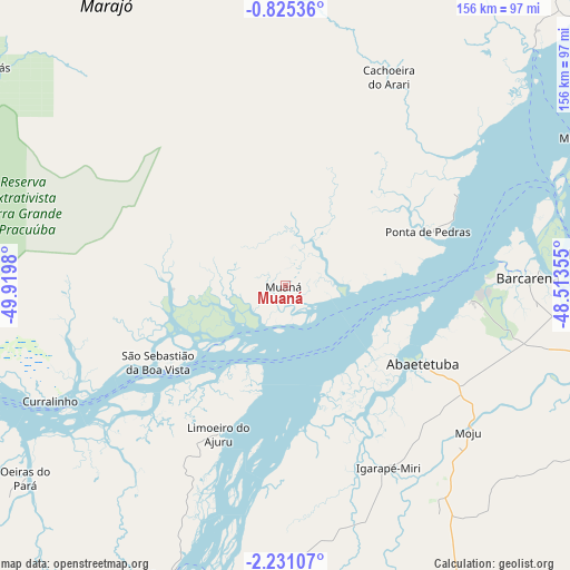
Muaná GPS coordinates[2]
1° 31' 41.988" South, 49° 13' 0.012" West
| Map corner | latitude | longitude |
|---|---|---|
| Upper-left | -0.82536°, | -49.9198° |
| Center: | -1.52833°, | -49.21667° |
| Lower-right: | -2.23107°, | -48.51355° |
| Map W x H: | 156.3×156.3 km | = 97.1×97.1mi |
| max Lat: | 2.81972° ⇑1.7% North |
| Muaná: | -1.52833° |
| min Lat: | ⇓98.3% South -33.69111° |
| min Long | Muaná | max Long |
| -72.89583° | -49.21667° | -32.41083° |
| W 26.9%⇐ | ⇒73.1% E |
Elevation
Elevation of Muaná is 7 m = 23 ft, and this is 373.9 m = 1227 ft below average elevation for this country.
| Max E: |
1603 m = 5259 ft | 97.2% |
| Avg. | 380.9 m = 1250 ft | |
| Muaná | 7 m = 23 ft | |
Min E: |
0 m = 0 ft | 2.8% |
See also: Brazil elevation on elevation.city.
Geographical zone
Muaná is located in South Torrid zone (between Equator and Tropic of Capricorn). Distance of Equator is 169.9 km =105.6 mi to North.| Distance of | km | miles | from Muaná |
|---|---|---|---|
| Equator | 169.9 | 105.6 | to North |
| Tropic Capricorn | 2436 | 1513.7 | to South |
| Antarctic Circle | 7231.2 | 4493.3 | to South |
| South Pole | 9837.1 | 6112.5 | to South |


Nearby cities:
15 places around Muaná: (largest is in red/bold)
• Abaetetuba
42.7 km =26.5 mi,  119°
119°
• Acará
123.1 km =76.5 mi,  112°
112°
• Ananindeua
95.6 km =59.4 mi,  79°
79°
• Barcarena
65.7 km =40.8 mi,  87°
87°
• Belém
79.6 km =49.5 mi, 84°
• Benevides
109.6 km =68.1 mi, 80°
• Bujaru
130.3 km =81 mi, 89°
• Cametá
85.5 km =53.1 mi,  201°
201°
• Igarapé Miri
57.3 km =35.6 mi,  150°
150°
• Limoeiro do Ajuru
44.7 km =27.8 mi, 204°
• Mocajuba
121.8 km =75.7 mi, 195°
• Moju
63.6 km =39.5 mi,  128°
128°
• Oeiras do Pará
88.4 km =54.9 mi,  233°
233°
• Santo Antônio do Tauá
127.9 km =79.5 mi,  70°
70°
• Soure
118.7 km =73.8 mi,  40°
40°
Sources, notices
• [Note1] Compared only with cities in Brazil existing in our database
• [Src1] Map data: © OpenStreetMap contributors (CC-BY-SA)
• [Src2] Other city data from geonames.org with taken over terms of usage.
• [Src3] Geographical zone / Annual Mean Temperature by Robert A. Rohde @ Wikipedia
