Moju geodata
Moju (Pará) is a populated place; located in Brazil in America/Belem (GMT-3) time zone. With population of 21,510 people, there are 885 cities with bigger population in this country. Compared to other cities in Brazil, 97.7% of cities are located further ↓South; 69.9% of cities are located further →East and 95.4% of cities have higher elevation than Moju. Note1


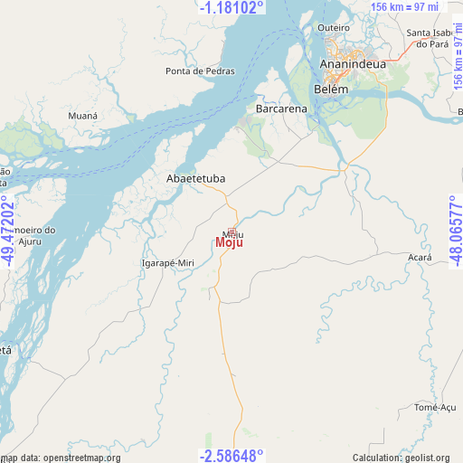
Moju GPS coordinates[2]
1° 53' 2.004" South, 48° 46' 8.004" West
| Map corner | latitude | longitude |
|---|---|---|
| Upper-left | -1.18102°, | -49.47202° |
| Center: | -1.88389°, | -48.76889° |
| Lower-right: | -2.58648°, | -48.06577° |
| Map W x H: | 156.3×156.3 km | = 97.1×97.1mi |
| max Lat: | 2.81972° ⇑2.3% North |
| Moju: | -1.88389° |
| min Lat: | ⇓97.7% South -33.69111° |
| min Long | Moju | max Long |
| -72.89583° | -48.76889° | -32.41083° |
| W 30.1%⇐ | ⇒69.9% E |
Elevation
Elevation of Moju is 9 m = 30 ft, and this is 371.9 m = 1220 ft below average elevation for this country.
| Max E: |
1603 m = 5259 ft | 95.4% |
| Avg. | 380.9 m = 1250 ft | |
| Moju | 9 m = 30 ft | |
Min E: |
0 m = 0 ft | 4.6% |
See also: Brazil elevation on elevation.city.
Geographical zone
Moju is located in South Torrid zone (between Equator and Tropic of Capricorn). Distance of Equator is 209.5 km =130.2 mi to North.| Distance of | km | miles | from Moju |
|---|---|---|---|
| Equator | 209.5 | 130.2 | to North |
| Tropic Capricorn | 2396.5 | 1489.1 | to South |
| Antarctic Circle | 7191.7 | 4468.7 | to South |
| South Pole | 9797.6 | 6087.9 | to South |


Nearby cities:
15 places around Moju: (largest is in red/bold)
• Abaetetuba
22.3 km =13.9 mi,  325°
325°
• Acará
64.2 km =39.9 mi,  97°
97°
• Ananindeua
72.6 km =45.1 mi,  37°
37°
• Barcarena
44.9 km =27.9 mi,  20°
20°
• Belém
55.9 km =34.7 mi,  31°
31°
• Benevides
82.3 km =51.1 mi,  45°
45°
• Bujaru
90.3 km =56.1 mi,  62°
62°
• Cametá
90.2 km =56 mi,  243°
243°
• Castanhal
114.3 km =71 mi, 54°
• Igarapé Miri
23.5 km =14.6 mi, 244°
• Limoeiro do Ajuru
68 km =42.3 mi,  268°
268°
• Mocajuba
113.1 km =70.3 mi,  226°
226°
• Muaná
63.6 km =39.5 mi,  308°
308°
• Santo Antônio do Tauá
108.1 km =67.2 mi, 41°
• Tomé Açu
90.7 km =56.4 mi,  130°
130°
Sources, notices
• [Note1] Compared only with cities in Brazil existing in our database
• [Src1] Map data: © OpenStreetMap contributors (CC-BY-SA)
• [Src2] Other city data from geonames.org with taken over terms of usage.
• [Src3] Geographical zone / Annual Mean Temperature by Robert A. Rohde @ Wikipedia
