Belém geodata
Belém (Pará) is a seat of a first-order administrative division; located in Brazil in America/Belem (GMT-3) time zone. With population of 1,407,737 people, there are 9 cities with bigger population in this country. Compared to other cities in Brazil, 98.5% of cities are located further ↓South; 67% of cities are located further →East and 91.4% of cities have higher elevation than Belém. Note1


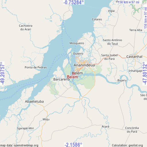
Belém GPS coordinates[2]
1° 27' 20.988" South, 48° 30' 15.984" West
| Map corner | latitude | longitude |
|---|---|---|
| Upper-left | -0.75284°, | -49.20757° |
| Center: | -1.45583°, | -48.50444° |
| Lower-right: | -2.1586°, | -47.80132° |
| Map W x H: | 156.3×156.3 km | = 97.1×97.1mi |
| max Lat: | 2.81972° ⇑1.5% North |
| Belém: | -1.45583° |
| min Lat: | ⇓98.5% South -33.69111° |
| min Long | Belém | max Long |
| -72.89583° | -48.50444° | -32.41083° |
| W 33%⇐ | ⇒67% E |
Elevation
Elevation of Belém is 15 m = 49 ft, and this is 365.9 m = 1200 ft below average elevation for this country.
| Max E: |
1603 m = 5259 ft | 91.4% |
| Avg. | 380.9 m = 1250 ft | |
| Belém | 15 m = 49 ft | |
Min E: |
0 m = 0 ft | 8.6% |
See also: Belém elevation on elevation.city.
Geographical zone
Belém is located in South Torrid zone (between Equator and Tropic of Capricorn). Distance of Equator is 161.9 km =100.6 mi to North.| Distance of | km | miles | from Belém |
|---|---|---|---|
| Equator | 161.9 | 100.6 | to North |
| Tropic Capricorn | 2444 | 1518.6 | to South |
| Antarctic Circle | 7239.3 | 4498.3 | to South |
| South Pole | 9845.2 | 6117.5 | to South |


Nearby cities:
15 places around Belém: (largest is in red/bold)
• Abaetetuba
51.1 km =31.8 mi,  235°
235°
• Acará
65.7 km =40.8 mi,  148°
148°
• Ananindeua
17.8 km =11.1 mi,  55°
55°
• Barcarena
14.6 km =9.1 mi,  247°
247°
• Benevides
30.7 km =19.1 mi,  70°
70°
• Bujaru
51.5 km =32 mi,  97°
97°
• Castanhal
66.7 km =41.4 mi, 74°
• Igarapé Miri
76.8 km =47.7 mi,  221°
221°
• Moju
55.9 km =34.7 mi,  211°
211°
• Muaná
79.6 km =49.5 mi,  264°
264°
• Santa Maria do Pará
103.9 km =64.6 mi,  83°
83°
• Santo Antônio do Tauá
53.7 km =33.4 mi,  50°
50°
• Soure
82.2 km =51.1 mi,  358°
358°
• São Caetano de Odivelas
95.2 km =59.2 mi,  34°
34°
• Vigia
77.7 km =48.3 mi, 31°
Sources, notices
• [Note1] Compared only with cities in Brazil existing in our database
• [Src1] Map data: © OpenStreetMap contributors (CC-BY-SA)
• [Src2] Other city data from geonames.org with taken over terms of usage.
• [Src3] Geographical zone / Annual Mean Temperature by Robert A. Rohde @ Wikipedia
