Inhuma geodata
Inhuma (Piauí) is a populated place; located in Brazil in America/Fortaleza (GMT-3) time zone. With population of 7,056 people, there are 1827 cities with bigger population in this country. Compared to other cities in Brazil, 82.1% of cities are located further ↓South; 67.2% of cities are located further ←West and 52.8% of cities have lower elevation than Inhuma. Note1


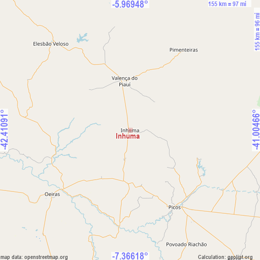
Inhuma GPS coordinates[2]
6° 40' 5.988" South, 41° 42' 28.008" West
| Map corner | latitude | longitude |
|---|---|---|
| Upper-left | -5.96948°, | -42.41091° |
| Center: | -6.66833°, | -41.70778° |
| Lower-right: | -7.36618°, | -41.00466° |
| Map W x H: | 155.3×155.3 km | = 96.5×96.5mi |
| max Lat: | 2.81972° ⇑17.9% North |
| Inhuma: | -6.66833° |
| min Lat: | ⇓82.1% South -33.69111° |
| min Long | Inhuma | max Long |
| -72.89583° | -41.70778° | -32.41083° |
| W 67.2%⇐ | ⇒32.8% E |
Elevation
Elevation of Inhuma is 391 m = 1283 ft, and this is 10.1 m = 33 ft above average elevation for this country.
| Max E: |
1603 m = 5259 ft | 47.2% |
| Inhuma | 391 m 1283 ft | |
| Avg. | 380.9 m = 1250 ft | |
Min E: |
0 m = 0 ft | 52.8% |
See also: Brazil elevation on elevation.city.
Geographical zone
Inhuma is located in South Torrid zone (between Equator and Tropic of Capricorn). Distance of Equator is 741.4 km =460.7 mi to North.| Distance of | km | miles | from Inhuma |
|---|---|---|---|
| Equator | 741.4 | 460.7 | to North |
| Tropic Capricorn | 1864.5 | 1158.5 | to South |
| Antarctic Circle | 6659.7 | 4138.1 | to South |
| South Pole | 9265.6 | 5757.4 | to South |


Nearby cities:
15 places around Inhuma: (largest is in red/bold)
• Amarante
134.3 km =83.5 mi,  290°
290°
• Elesbão Veloso
70.5 km =43.8 mi,  317°
317°
• Itainópolis
90.2 km =56 mi,  163°
163°
• Jaicós
99.3 km =61.7 mi,  140°
140°
• Oeiras
61.3 km =38.1 mi,  229°
229°
• Parambu
123 km =76.4 mi,  65°
65°
• Picos
52.6 km =32.7 mi,  149°
149°
• Pimenteiras
56.8 km =35.3 mi,  34°
34°
• Pio IX
126 km =78.3 mi,  98°
98°
• Regeneração
118.6 km =73.7 mi, 294°
• Simplício Mendes
133.7 km =83.1 mi,  189°
189°
• São Miguel do Tapuio
136.3 km =84.7 mi,  18°
18°
• São Pedro do Piauí
138.7 km =86.2 mi,  306°
306°
• Valença do Piauí
29.3 km =18.2 mi,  351°
351°
• Água Branca
134.1 km =83.3 mi, 310°
Sources, notices
• [Note1] Compared only with cities in Brazil existing in our database
• [Src1] Map data: © OpenStreetMap contributors (CC-BY-SA)
• [Src2] Other city data from geonames.org with taken over terms of usage.
• [Src3] Geographical zone / Annual Mean Temperature by Robert A. Rohde @ Wikipedia
