Regeneração geodata
Regeneração (Piauí) is a populated place; located in Brazil in America/Fortaleza (GMT-3) time zone. With population of 13,608 people, there are 1320 cities with bigger population in this country. Compared to other cities in Brazil, 84.3% of cities are located further ↓South; 62.5% of cities are located further ←West and 63.9% of cities have higher elevation than Regeneração. Note1


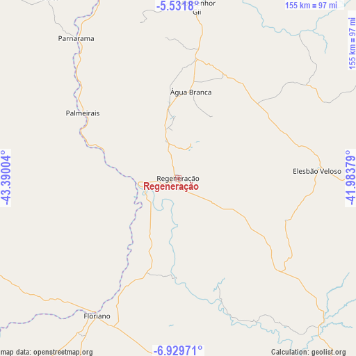
Regeneração GPS coordinates[2]
6° 13' 52.392" South, 42° 41' 12.876" West
| Map corner | latitude | longitude |
|---|---|---|
| Upper-left | -5.5318°, | -43.39004° |
| Center: | -6.23122°, | -42.68691° |
| Lower-right: | -6.92971°, | -41.98379° |
| Map W x H: | 155.4×155.4 km | = 96.6×96.6mi |
| max Lat: | 2.81972° ⇑15.7% North |
| Regeneração: | -6.23122° |
| min Lat: | ⇓84.3% South -33.69111° |
| min Long | Regeneração | max Long |
| -72.89583° | -42.68691° | -32.41083° |
| W 62.5%⇐ | ⇒37.5% E |
Elevation
Elevation of Regeneração is 177 m = 581 ft, and this is 203.9 m = 669 ft below average elevation for this country.
| Max E: |
1603 m = 5259 ft | 63.9% |
| Avg. | 380.9 m = 1250 ft | |
| Regeneração | 177 m = 581 ft | |
Min E: |
0 m = 0 ft | 36.1% |
See also: Brazil elevation on elevation.city.
Geographical zone
Regeneração is located in South Torrid zone (between Equator and Tropic of Capricorn). Distance of Equator is 692.8 km =430.5 mi to North.| Distance of | km | miles | from Regeneração |
|---|---|---|---|
| Equator | 692.8 | 430.5 | to North |
| Tropic Capricorn | 1913.1 | 1188.7 | to South |
| Antarctic Circle | 6708.3 | 4168.3 | to South |
| South Pole | 9314.2 | 5787.6 | to South |


Nearby cities:
15 places around Regeneração: (largest is in red/bold)
• Amarante
17.6 km =10.9 mi,  265°
265°
• Beneditinos
93.8 km =58.3 mi,  22°
22°
• Demerval Lobão
97.1 km =60.3 mi,  0°
0°
• Elesbão Veloso
60.5 km =37.6 mi,  86°
86°
• Estreito
79.7 km =49.5 mi,  308°
308°
• Floriano
70.2 km =43.6 mi,  211°
211°
• Inhuma
118.6 km =73.7 mi,  114°
114°
• Monsenhor Gil
74.7 km =46.4 mi,  6°
6°
• Oeiras
107.5 km =66.8 mi,  145°
145°
• Palmeirais
50.3 km =31.3 mi,  304°
304°
• Parnarama
75.9 km =47.2 mi,  323°
323°
• São João dos Patos
116 km =72.1 mi,  255°
255°
• São Pedro do Piauí
33.7 km =20.9 mi,  354°
354°
• Valença do Piauí
105.9 km =65.8 mi,  100°
100°
• Água Branca
38.1 km =23.7 mi, 8°
Sources, notices
• [Note1] Compared only with cities in Brazil existing in our database
• [Src1] Map data: © OpenStreetMap contributors (CC-BY-SA)
• [Src2] Other city data from geonames.org with taken over terms of usage.
• [Src3] Geographical zone / Annual Mean Temperature by Robert A. Rohde @ Wikipedia
