Amarante geodata
Amarante (Piauí) is a populated place; located in Brazil in America/Fortaleza (GMT-3) time zone. With population of 8,828 people, there are 1731 cities with bigger population in this country. Compared to other cities in Brazil, 84.2% of cities are located further ↓South; 61.4% of cities are located further ←West and 72.1% of cities have higher elevation than Amarante. Note1


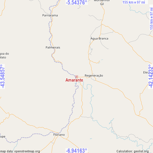
Amarante GPS coordinates[2]
6° 14' 35.376" South, 42° 50' 43.584" West
| Map corner | latitude | longitude |
|---|---|---|
| Upper-left | -5.54376°, | -43.54857° |
| Center: | -6.24316°, | -42.84544° |
| Lower-right: | -6.94163°, | -42.14232° |
| Map W x H: | 155.4×155.4 km | = 96.6×96.6mi |
| max Lat: | 2.81972° ⇑15.8% North |
| Amarante: | -6.24316° |
| min Lat: | ⇓84.2% South -33.69111° |
| min Long | Amarante | max Long |
| -72.89583° | -42.84544° | -32.41083° |
| W 61.4%⇐ | ⇒38.6% E |
Elevation
Elevation of Amarante is 102 m = 335 ft, and this is 278.9 m = 915 ft below average elevation for this country.
| Max E: |
1603 m = 5259 ft | 72.1% |
| Avg. | 380.9 m = 1250 ft | |
| Amarante | 102 m = 335 ft | |
Min E: |
0 m = 0 ft | 27.9% |
See also: Brazil elevation on elevation.city.
Geographical zone
Amarante is located in South Torrid zone (between Equator and Tropic of Capricorn). Distance of Equator is 694.2 km =431.4 mi to North.| Distance of | km | miles | from Amarante |
|---|---|---|---|
| Equator | 694.2 | 431.4 | to North |
| Tropic Capricorn | 1911.7 | 1187.9 | to South |
| Antarctic Circle | 6707 | 4167.5 | to South |
| South Pole | 9312.9 | 5786.8 | to South |


Nearby cities:
15 places around Amarante: (largest is in red/bold)
• Beneditinos
102.9 km =63.9 mi,  30°
30°
• Buriti Bravo
118.2 km =73.4 mi,  292°
292°
• Demerval Lobão
100.1 km =62.2 mi,  10°
10°
• Elesbão Veloso
78.1 km =48.5 mi,  86°
86°
• Estreito
67.9 km =42.2 mi,  318°
318°
• Floriano
61.4 km =38.2 mi,  198°
198°
• Monsenhor Gil
79.9 km =49.6 mi,  19°
19°
• Oeiras
117.4 km =72.9 mi,  137°
137°
• Palmeirais
38.1 km =23.7 mi, 320°
• Parnarama
68.2 km =42.4 mi,  336°
336°
• Passagem Franca
103.9 km =64.6 mi,  273°
273°
• Regeneração
17.6 km =10.9 mi, 85°
• São João dos Patos
98.7 km =61.3 mi,  253°
253°
• São Pedro do Piauí
37.6 km =23.4 mi, 21°
• Água Branca
45.4 km =28.2 mi, 30°
Sources, notices
• [Note1] Compared only with cities in Brazil existing in our database
• [Src1] Map data: © OpenStreetMap contributors (CC-BY-SA)
• [Src2] Other city data from geonames.org with taken over terms of usage.
• [Src3] Geographical zone / Annual Mean Temperature by Robert A. Rohde @ Wikipedia
