Extremoz geodata
Extremoz (Rio Grande do Norte) is a populated place; located in Brazil in America/Fortaleza (GMT-3) time zone. With population of 17,991 people, there are 1045 cities with bigger population in this country. Compared to other cities in Brazil, 86.3% of cities are located further ↓South; 97.3% of cities are located further ←West and 79.6% of cities have higher elevation than Extremoz. Note1


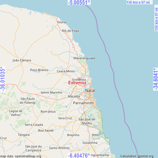
Extremoz GPS coordinates[2]
5° 42' 20.016" South, 35° 18' 25.992" West
| Map corner | latitude | longitude |
|---|---|---|
| Upper-left | -5.00551°, | -36.01035° |
| Center: | -5.70556°, | -35.30722° |
| Lower-right: | -6.40476°, | -34.6041° |
| Map W x H: | 155.6×155.6 km | = 96.7×96.7mi |
| max Lat: | 2.81972° ⇑13.7% North |
| Extremoz: | -5.70556° |
| min Lat: | ⇓86.3% South -33.69111° |
| min Long | Extremoz | max Long |
| -72.89583° | -35.30722° | -32.41083° |
| W 97.3%⇐ | ⇒2.7% E |
Elevation
Elevation of Extremoz is 48 m = 157 ft, and this is 332.9 m = 1092 ft below average elevation for this country.
| Max E: |
1603 m = 5259 ft | 79.6% |
| Avg. | 380.9 m = 1250 ft | |
| Extremoz | 48 m = 157 ft | |
Min E: |
0 m = 0 ft | 20.4% |
See also: Brazil elevation on elevation.city.
Geographical zone
Extremoz is located in South Torrid zone (between Equator and Tropic of Capricorn). Distance of Equator is 634.4 km =394.2 mi to North.| Distance of | km | miles | from Extremoz |
|---|---|---|---|
| Equator | 634.4 | 394.2 | to North |
| Tropic Capricorn | 1971.5 | 1225 | to South |
| Antarctic Circle | 6766.8 | 4204.7 | to South |
| South Pole | 9372.7 | 5823.9 | to South |


Nearby cities:
15 places around Extremoz: (largest is in red/bold)
• Arês
56.7 km =35.2 mi,  163°
163°
• Brejinho
54.2 km =33.7 mi,  185°
185°
• Ceará Mirim
15.3 km =9.5 mi,  301°
301°
• João Câmara
59.7 km =37.1 mi,  288°
288°
• Macaíba
17.8 km =11.1 mi,  196°
196°
• Natal
14.7 km =9.1 mi,  132°
132°
• Nísia Floresta
44.2 km =27.5 mi,  165°
165°
• Parnamirim
23.9 km =14.9 mi, 168°
• Poço Branco
40.4 km =25.1 mi,  283°
283°
• São Gonçalo do Amarante
10.1 km =6.3 mi, 194°
• São José de Mipibu
41.8 km =26 mi, 169°
• São Miguel
27.4 km =17 mi,  346°
346°
• São Paulo do Potengi
54.6 km =33.9 mi,  247°
247°
• Taipu
33.4 km =20.8 mi, 286°
• Touros
58.8 km =36.5 mi,  343°
343°
Sources, notices
• [Note1] Compared only with cities in Brazil existing in our database
• [Src1] Map data: © OpenStreetMap contributors (CC-BY-SA)
• [Src2] Other city data from geonames.org with taken over terms of usage.
• [Src3] Geographical zone / Annual Mean Temperature by Robert A. Rohde @ Wikipedia
