Natal geodata
Natal (Rio Grande do Norte) is a seat of a first-order administrative division; located in Brazil in America/Fortaleza (GMT-3) time zone. With population of 763,043 people, there are 18 cities with bigger population in this country. Compared to other cities in Brazil, 86% of cities are located further ↓South; 98.1% of cities are located further ←West and 84.4% of cities have higher elevation than Natal. Note1


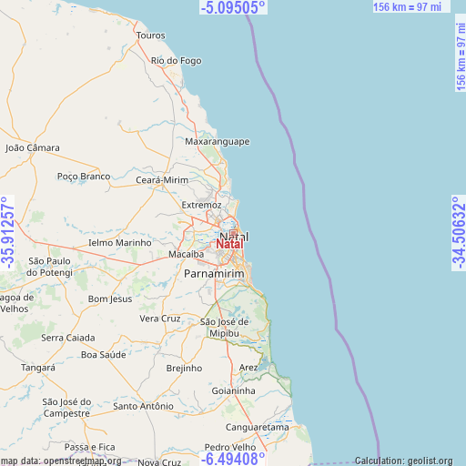
Natal GPS coordinates[2]
5° 47' 42" South, 35° 12' 33.984" West
| Map corner | latitude | longitude |
|---|---|---|
| Upper-left | -5.09505°, | -35.91257° |
| Center: | -5.795°, | -35.20944° |
| Lower-right: | -6.49408°, | -34.50632° |
| Map W x H: | 155.6×155.6 km | = 96.7×96.7mi |
| max Lat: | 2.81972° ⇑14% North |
| Natal: | -5.795° |
| min Lat: | ⇓86% South -33.69111° |
| min Long | Natal | max Long |
| -72.89583° | -35.20944° | -32.41083° |
| W 98.1%⇐ | ⇒1.9% E |
Elevation
Elevation of Natal is 32 m = 105 ft, and this is 348.9 m = 1145 ft below average elevation for this country.
| Max E: |
1603 m = 5259 ft | 84.4% |
| Avg. | 380.9 m = 1250 ft | |
| Natal | 32 m = 105 ft | |
Min E: |
0 m = 0 ft | 15.6% |
See also: Natal elevation on elevation.city.
Geographical zone
Natal is located in South Torrid zone (between Equator and Tropic of Capricorn). Distance of Equator is 644.3 km =400.3 mi to North.| Distance of | km | miles | from Natal |
|---|---|---|---|
| Equator | 644.3 | 400.3 | to North |
| Tropic Capricorn | 1961.6 | 1218.9 | to South |
| Antarctic Circle | 6756.8 | 4198.5 | to South |
| South Pole | 9362.7 | 5817.7 | to South |


Nearby cities:
15 places around Natal: (largest is in red/bold)
• Arês
44.7 km =27.8 mi,  173°
173°
• Brejinho
46.9 km =29.1 mi,  200°
200°
• Ceará Mirim
29.8 km =18.5 mi,  306°
306°
• Extremoz
14.7 km =9.1 mi, 312°
• Goianinha
52.2 km =32.4 mi,  180°
180°
• Macaíba
17.5 km =10.9 mi,  246°
246°
• Nísia Floresta
32.9 km =20.4 mi, 179°
• Parnamirim
14.6 km =9.1 mi, 203°
• Poço Branco
53.7 km =33.4 mi,  290°
290°
• Santo Antônio
64.6 km =40.1 mi,  207°
207°
• São Gonçalo do Amarante
13.3 km =8.3 mi,  270°
270°
• São José de Mipibu
31.3 km =19.4 mi,  185°
185°
• São Miguel
40.4 km =25.1 mi,  334°
334°
• São Paulo do Potengi
62.2 km =38.6 mi,  259°
259°
• Taipu
47 km =29.2 mi, 294°
Sources, notices
• [Note1] Compared only with cities in Brazil existing in our database
• [Src1] Map data: © OpenStreetMap contributors (CC-BY-SA)
• [Src2] Other city data from geonames.org with taken over terms of usage.
• [Src3] Geographical zone / Annual Mean Temperature by Robert A. Rohde @ Wikipedia
