Nísia Floresta geodata
Nísia Floresta (Rio Grande do Norte) is a populated place; located in Brazil in America/Fortaleza (GMT-3) time zone. With population of 10,115 people, there are 1638 cities with bigger population in this country. Compared to other cities in Brazil, 84.9% of cities are located further ↓South; 98.1% of cities are located further ←West and 89.5% of cities have higher elevation than Nísia Floresta. Note1


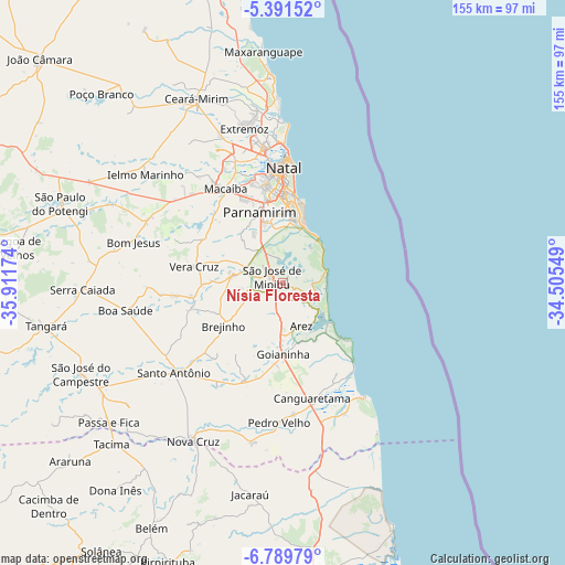
Nísia Floresta GPS coordinates[2]
6° 5' 27.996" South, 35° 12' 30.996" West
| Map corner | latitude | longitude |
|---|---|---|
| Upper-left | -5.39152°, | -35.91174° |
| Center: | -6.09111°, | -35.20861° |
| Lower-right: | -6.78979°, | -34.50549° |
| Map W x H: | 155.5×155.5 km | = 96.6×96.6mi |
| max Lat: | 2.81972° ⇑15.1% North |
| Nísia Floresta: | -6.09111° |
| min Lat: | ⇓84.9% South -33.69111° |
| min Long | Nísia Floresta | max Long |
| -72.89583° | -35.20861° | -32.41083° |
| W 98.1%⇐ | ⇒1.9% E |
Elevation
Elevation of Nísia Floresta is 19 m = 62 ft, and this is 361.9 m = 1187 ft below average elevation for this country.
| Max E: |
1603 m = 5259 ft | 89.5% |
| Avg. | 380.9 m = 1250 ft | |
| Nísia Floresta | 19 m = 62 ft | |
Min E: |
0 m = 0 ft | 10.5% |
See also: Brazil elevation on elevation.city.
Geographical zone
Nísia Floresta is located in South Torrid zone (between Equator and Tropic of Capricorn). Distance of Equator is 677.3 km =420.9 mi to North.| Distance of | km | miles | from Nísia Floresta |
|---|---|---|---|
| Equator | 677.3 | 420.9 | to North |
| Tropic Capricorn | 1928.7 | 1198.4 | to South |
| Antarctic Circle | 6723.9 | 4178 | to South |
| South Pole | 9329.8 | 5797.3 | to South |


Nearby cities:
15 places around Nísia Floresta: (largest is in red/bold)
• Arês
12.7 km =7.9 mi,  155°
155°
• Brejinho
19.8 km =12.3 mi,  235°
235°
• Canguaretama
33.3 km =20.7 mi, 164°
• Ceará Mirim
56.2 km =34.9 mi,  334°
334°
• Extremoz
44.2 km =27.5 mi,  345°
345°
• Goianinha
19.3 km =12 mi,  181°
181°
• Macaíba
30.5 km =19 mi, 328°
• Montanhas
44.7 km =27.8 mi,  191°
191°
• Natal
32.9 km =20.4 mi,  359°
359°
• Nova Cruz
49.7 km =30.9 mi,  210°
210°
• Parnamirim
20.4 km =12.7 mi,  342°
342°
• Pedro Velho
38.7 km =24 mi, 182°
• Santo Antônio
38.6 km =24 mi,  230°
230°
• São Gonçalo do Amarante
35.7 km =22.2 mi, 338°
• São José de Mipibu
3.7 km =2.3 mi,  299°
299°
Sources, notices
• [Note1] Compared only with cities in Brazil existing in our database
• [Src1] Map data: © OpenStreetMap contributors (CC-BY-SA)
• [Src2] Other city data from geonames.org with taken over terms of usage.
• [Src3] Geographical zone / Annual Mean Temperature by Robert A. Rohde @ Wikipedia
