Cantanhede geodata
Cantanhede (Maranhão) is a populated place; located in Brazil in America/Fortaleza (GMT-3) time zone. With population of 8,344 people, there are 1759 cities with bigger population in this country. Compared to other cities in Brazil, 92.9% of cities are located further ↓South; 53.8% of cities are located further ←West and 86.6% of cities have higher elevation than Cantanhede. Note1


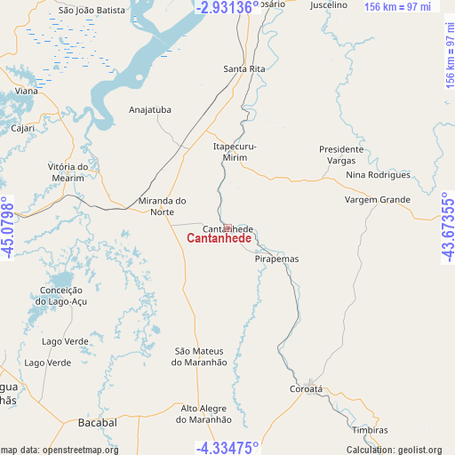
Cantanhede GPS coordinates[2]
3° 37' 59.988" South, 44° 22' 36.012" West
| Map corner | latitude | longitude |
|---|---|---|
| Upper-left | -2.93136°, | -45.0798° |
| Center: | -3.63333°, | -44.37667° |
| Lower-right: | -4.33475°, | -43.67355° |
| Map W x H: | 156×156 km | = 96.9×96.9mi |
| max Lat: | 2.81972° ⇑7.1% North |
| Cantanhede: | -3.63333° |
| min Lat: | ⇓92.9% South -33.69111° |
| min Long | Cantanhede | max Long |
| -72.89583° | -44.37667° | -32.41083° |
| W 53.8%⇐ | ⇒46.2% E |
Elevation
Elevation of Cantanhede is 25 m = 82 ft, and this is 355.9 m = 1168 ft below average elevation for this country.
| Max E: |
1603 m = 5259 ft | 86.6% |
| Avg. | 380.9 m = 1250 ft | |
| Cantanhede | 25 m = 82 ft | |
Min E: |
0 m = 0 ft | 13.4% |
See also: Brazil elevation on elevation.city.
Geographical zone
Cantanhede is located in South Torrid zone (between Equator and Tropic of Capricorn). Distance of Equator is 404 km =251 mi to North.| Distance of | km | miles | from Cantanhede |
|---|---|---|---|
| Equator | 404 | 251 | to North |
| Tropic Capricorn | 2201.9 | 1368.2 | to South |
| Antarctic Circle | 6997.2 | 4347.9 | to South |
| South Pole | 9603.1 | 5967.1 | to South |


Nearby cities:
15 places around Cantanhede: (largest is in red/bold)
• Anajatuba
49.1 km =30.5 mi,  326°
326°
• Arari
49 km =30.4 mi,  294°
294°
• Bacabal
86.5 km =53.7 mi,  212°
212°
• Coroatá
61.9 km =38.5 mi,  153°
153°
• Itapecuru Mirim
26.9 km =16.7 mi,  4°
4°
• Matinha
93.9 km =58.3 mi,  309°
309°
• Pio XII
88.9 km =55.2 mi,  255°
255°
• Pirapemas
19.9 km =12.4 mi,  121°
121°
• Santa Rita
62.8 km =39 mi,  114°
114°
• São João Batista
89.2 km =55.4 mi, 327°
• São Mateus do Maranhão
46.7 km =29 mi,  193°
193°
• Timbiras
84.4 km =52.4 mi, 145°
• Vargem Grande
52.1 km =32.4 mi,  78°
78°
• Viana
83.4 km =51.8 mi,  303°
303°
• Vitória do Mearim
58 km =36 mi, 289°
Sources, notices
• [Note1] Compared only with cities in Brazil existing in our database
• [Src1] Map data: © OpenStreetMap contributors (CC-BY-SA)
• [Src2] Other city data from geonames.org with taken over terms of usage.
• [Src3] Geographical zone / Annual Mean Temperature by Robert A. Rohde @ Wikipedia
