Pirapemas geodata
Pirapemas (Maranhão) is a populated place; located in Brazil in America/Fortaleza (GMT-3) time zone. With population of 6,439 people, there are 1859 cities with bigger population in this country. Compared to other cities in Brazil, 92.5% of cities are located further ↓South; 54.7% of cities are located further ←West and 83% of cities have higher elevation than Pirapemas. Note1


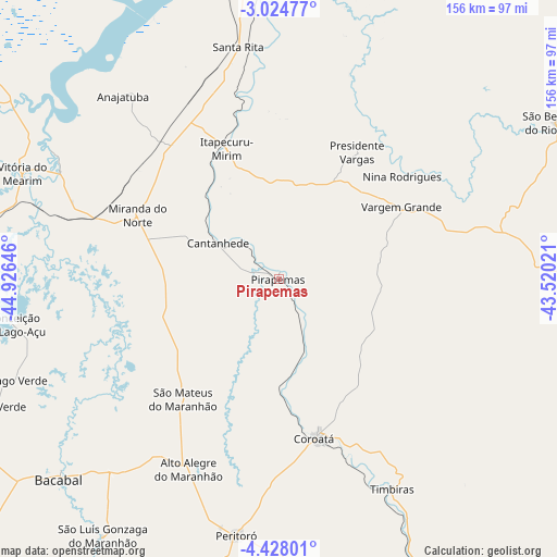
Pirapemas GPS coordinates[2]
3° 43' 36.012" South, 44° 13' 23.988" West
| Map corner | latitude | longitude |
|---|---|---|
| Upper-left | -3.02477°, | -44.92646° |
| Center: | -3.72667°, | -44.22333° |
| Lower-right: | -4.42801°, | -43.52021° |
| Map W x H: | 156×156 km | = 96.9×96.9mi |
| max Lat: | 2.81972° ⇑7.5% North |
| Pirapemas: | -3.72667° |
| min Lat: | ⇓92.5% South -33.69111° |
| min Long | Pirapemas | max Long |
| -72.89583° | -44.22333° | -32.41083° |
| W 54.7%⇐ | ⇒45.3% E |
Elevation
Elevation of Pirapemas is 36 m = 118 ft, and this is 344.9 m = 1132 ft below average elevation for this country.
| Max E: |
1603 m = 5259 ft | 83% |
| Avg. | 380.9 m = 1250 ft | |
| Pirapemas | 36 m = 118 ft | |
Min E: |
0 m = 0 ft | 17% |
See also: Brazil elevation on elevation.city.
Geographical zone
Pirapemas is located in South Torrid zone (between Equator and Tropic of Capricorn). Distance of Equator is 414.4 km =257.5 mi to North.| Distance of | km | miles | from Pirapemas |
|---|---|---|---|
| Equator | 414.4 | 257.5 | to North |
| Tropic Capricorn | 2191.6 | 1361.8 | to South |
| Antarctic Circle | 6986.8 | 4341.4 | to South |
| South Pole | 9592.7 | 5960.6 | to South |


Nearby cities:
15 places around Pirapemas: (largest is in red/bold)
• Anajatuba
67.7 km =42.1 mi,  319°
319°
• Arari
68.8 km =42.8 mi,  296°
296°
• Bacabal
89 km =55.3 mi,  225°
225°
• Cantanhede
19.9 km =12.4 mi, 301°
• Chapadinha
95.8 km =59.5 mi,  90°
90°
• Codó
89.3 km =55.5 mi,  155°
155°
• Coroatá
46.2 km =28.7 mi,  166°
166°
• Itapecuru Mirim
40.1 km =24.9 mi,  337°
337°
• Santa Rita
43.1 km =26.8 mi,  110°
110°
• São Benedito do Rio Preto
88.7 km =55.1 mi,  60°
60°
• São Mateus do Maranhão
44.8 km =27.8 mi,  218°
218°
• Timbiras
66.6 km =41.4 mi,  151°
151°
• Vargem Grande
39.8 km =24.7 mi, 59°
• Viana
103.3 km =64.2 mi, 303°
• Vitória do Mearim
77.6 km =48.2 mi,  292°
292°
Sources, notices
• [Note1] Compared only with cities in Brazil existing in our database
• [Src1] Map data: © OpenStreetMap contributors (CC-BY-SA)
• [Src2] Other city data from geonames.org with taken over terms of usage.
• [Src3] Geographical zone / Annual Mean Temperature by Robert A. Rohde @ Wikipedia
