São João Batista geodata
São João Batista (Maranhão) is a populated place; located in Brazil in America/Fortaleza (GMT-3) time zone. With population of 3,634 people, there are 1976 cities with bigger population in this country. Compared to other cities in Brazil, 95.5% of cities are located further ↓South; 52.4% of cities are located further ←West and 98.3% of cities have higher elevation than São João Batista. Note1


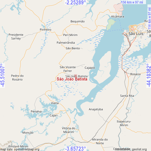
São João Batista GPS coordinates[2]
2° 57' 19.008" South, 44° 48' 24.984" West
| Map corner | latitude | longitude |
|---|---|---|
| Upper-left | -2.25289°, | -45.51007° |
| Center: | -2.95528°, | -44.80694° |
| Lower-right: | -3.65723°, | -44.10382° |
| Map W x H: | 156.1×156.2 km | = 97×97.1mi |
| max Lat: | 2.81972° ⇑4.5% North |
| São João Batista: | -2.95528° |
| min Lat: | ⇓95.5% South -33.69111° |
| min Long | São João Bati | max Long |
| -72.89583° | -44.80694° | -32.41083° |
| W 52.4%⇐ | ⇒47.6% E |
Elevation
Elevation of São João Batista is 6 m = 20 ft, and this is 374.9 m = 1230 ft below average elevation for this country.
| Max E: |
1603 m = 5259 ft | 98.3% |
| Avg. | 380.9 m = 1250 ft | |
| São João Batista | 6 m = 20 ft | |
Min E: |
0 m = 0 ft | 1.7% |
See also: Brazil elevation on elevation.city.
Geographical zone
São João Batista is located in South Torrid zone (between Equator and Tropic of Capricorn). Distance of Equator is 328.6 km =204.2 mi to North.| Distance of | km | miles | from São João Batista |
|---|---|---|---|
| Equator | 328.6 | 204.2 | to North |
| Tropic Capricorn | 2277.3 | 1415 | to South |
| Antarctic Circle | 7072.6 | 4394.7 | to South |
| South Pole | 9678.5 | 6013.9 | to South |


Nearby cities:
15 places around São João Batista: (largest is in red/bold)
• Alcântara
75.1 km =46.7 mi,  35°
35°
• Anajatuba
40.2 km =25 mi,  148°
148°
• Arari
55.5 km =34.5 mi,  176°
176°
• Bequimão
56.4 km =35 mi,  2°
2°
• Cantanhede
89.2 km =55.4 mi, 147°
• Icatu
84.7 km =52.6 mi,  76°
76°
• Itapecuru Mirim
69.6 km =43.2 mi,  134°
134°
• Matinha
29.9 km =18.6 mi,  237°
237°
• Monção
77.4 km =48.1 mi,  219°
219°
• Penalva
55.5 km =34.5 mi,  227°
227°
• Pinheiro
57.1 km =35.5 mi,  327°
327°
• São Bento
28.9 km =18 mi,  356°
356°
• São Luís
73.3 km =45.5 mi,  49°
49°
• Viana
36.7 km =22.8 mi, 216°
• Vitória do Mearim
56.8 km =35.3 mi,  187°
187°
Sources, notices
• [Note1] Compared only with cities in Brazil existing in our database
• [Src1] Map data: © OpenStreetMap contributors (CC-BY-SA)
• [Src2] Other city data from geonames.org with taken over terms of usage.
• [Src3] Geographical zone / Annual Mean Temperature by Robert A. Rohde @ Wikipedia
