Viana geodata
Viana (Maranhão) is a populated place; located in Brazil in America/Fortaleza (GMT-3) time zone. With population of 26,689 people, there are 740 cities with bigger population in this country. Compared to other cities in Brazil, 94.6% of cities are located further ↓South; 51.2% of cities are located further ←West and 92.4% of cities have higher elevation than Viana. Note1


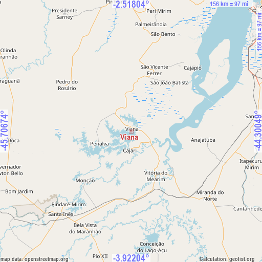
Viana GPS coordinates[2]
3° 13' 13.008" South, 45° 0' 12.996" West
| Map corner | latitude | longitude |
|---|---|---|
| Upper-left | -2.51804°, | -45.70674° |
| Center: | -3.22028°, | -45.00361° |
| Lower-right: | -3.92204°, | -44.30049° |
| Map W x H: | 156.1×156.1 km | = 97×97mi |
| max Lat: | 2.81972° ⇑5.4% North |
| Viana: | -3.22028° |
| min Lat: | ⇓94.6% South -33.69111° |
| min Long | Viana | max Long |
| -72.89583° | -45.00361° | -32.41083° |
| W 51.2%⇐ | ⇒48.8% E |
Elevation
Elevation of Viana is 13 m = 43 ft, and this is 367.9 m = 1207 ft below average elevation for this country.
| Max E: |
1603 m = 5259 ft | 92.4% |
| Avg. | 380.9 m = 1250 ft | |
| Viana | 13 m = 43 ft | |
Min E: |
0 m = 0 ft | 7.6% |
See also: Brazil elevation on elevation.city.
Geographical zone
Viana is located in South Torrid zone (between Equator and Tropic of Capricorn). Distance of Equator is 358.1 km =222.5 mi to North.| Distance of | km | miles | from Viana |
|---|---|---|---|
| Equator | 358.1 | 222.5 | to North |
| Tropic Capricorn | 2247.9 | 1396.8 | to South |
| Antarctic Circle | 7043.1 | 4376.4 | to South |
| South Pole | 9649 | 5995.6 | to South |


Nearby cities:
15 places around Viana: (largest is in red/bold)
• Anajatuba
42.9 km =26.7 mi,  96°
96°
• Araguanã
79.1 km =49.2 mi,  292°
292°
• Arari
35.9 km =22.3 mi,  136°
136°
• Cantanhede
83.4 km =51.8 mi,  123°
123°
• Itapecuru Mirim
74.1 km =46 mi, 104°
• Matinha
13.7 km =8.5 mi,  345°
345°
• Monção
40.8 km =25.4 mi,  222°
222°
• Penalva
20.6 km =12.8 mi,  246°
246°
• Pindaré Mirim
57.3 km =35.6 mi, 221°
• Pinheiro
78.2 km =48.6 mi, 353°
• Pio XII
70 km =43.5 mi,  193°
193°
• Santa Inês
64.9 km =40.3 mi, 220°
• São Bento
61.7 km =38.3 mi,  19°
19°
• São João Batista
36.7 km =22.8 mi,  36°
36°
• Vitória do Mearim
30.7 km =19.1 mi,  151°
151°
Sources, notices
• [Note1] Compared only with cities in Brazil existing in our database
• [Src1] Map data: © OpenStreetMap contributors (CC-BY-SA)
• [Src2] Other city data from geonames.org with taken over terms of usage.
• [Src3] Geographical zone / Annual Mean Temperature by Robert A. Rohde @ Wikipedia
