Batalha geodata
Batalha (Piauí) is a populated place; located in Brazil in America/Fortaleza (GMT-3) time zone. With population of 8,744 people, there are 1740 cities with bigger population in this country. Compared to other cities in Brazil, 91.3% of cities are located further ↓South; 65.5% of cities are located further ←West and 70.5% of cities have higher elevation than Batalha. Note1


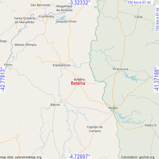
Batalha GPS coordinates[2]
4° 1' 30" South, 42° 4' 30" West
| Map corner | latitude | longitude |
|---|---|---|
| Upper-left | -3.32332°, | -42.77813° |
| Center: | -4.025°, | -42.075° |
| Lower-right: | -4.72607°, | -41.37188° |
| Map W x H: | 156×156 km | = 96.9×96.9mi |
| max Lat: | 2.81972° ⇑8.7% North |
| Batalha: | -4.025° |
| min Lat: | ⇓91.3% South -33.69111° |
| min Long | Batalha | max Long |
| -72.89583° | -42.075° | -32.41083° |
| W 65.5%⇐ | ⇒34.5% E |
Elevation
Elevation of Batalha is 119 m = 390 ft, and this is 261.9 m = 859 ft below average elevation for this country.
| Max E: |
1603 m = 5259 ft | 70.5% |
| Avg. | 380.9 m = 1250 ft | |
| Batalha | 119 m = 390 ft | |
Min E: |
0 m = 0 ft | 29.5% |
See also: Brazil elevation on elevation.city.
Geographical zone
Batalha is located in South Torrid zone (between Equator and Tropic of Capricorn). Distance of Equator is 447.5 km =278.1 mi to North.| Distance of | km | miles | from Batalha |
|---|---|---|---|
| Equator | 447.5 | 278.1 | to North |
| Tropic Capricorn | 2158.4 | 1341.2 | to South |
| Antarctic Circle | 6953.6 | 4320.8 | to South |
| South Pole | 9559.5 | 5940 | to South |


Nearby cities:
15 places around Batalha: (largest is in red/bold)
• Barras
34.5 km =21.4 mi,  224°
224°
• Brejo
83.9 km =52.1 mi,  296°
296°
• Buriti dos Lopes
97.3 km =60.5 mi,  13°
13°
• Campo Maior
89.9 km =55.9 mi,  186°
186°
• Cocal
84.1 km =52.3 mi,  43°
43°
• Esperantina
22.3 km =13.9 mi,  307°
307°
• Luzilândia
71.1 km =44.2 mi,  332°
332°
• Matias Olímpio
63.4 km =39.4 mi, 302°
• Miguel Alves
92.3 km =57.4 mi,  260°
260°
• Pedro II
81.5 km =50.6 mi,  123°
123°
• Piracuruca
42 km =26.1 mi,  75°
75°
• Piripiri
43.1 km =26.8 mi,  129°
129°
• Porto
71.9 km =44.7 mi,  281°
281°
• Santa Quitéria do Maranhão
77.1 km =47.9 mi,  317°
317°
• São Bernardo
83 km =51.6 mi, 332°
Sources, notices
• [Note1] Compared only with cities in Brazil existing in our database
• [Src1] Map data: © OpenStreetMap contributors (CC-BY-SA)
• [Src2] Other city data from geonames.org with taken over terms of usage.
• [Src3] Geographical zone / Annual Mean Temperature by Robert A. Rohde @ Wikipedia
