Parnarama geodata
Parnarama (Maranhão) is a populated place; located in Brazil in America/Fortaleza (GMT-3) time zone. With population of 12,201 people, there are 1460 cities with bigger population in this country. Compared to other cities in Brazil, 86.4% of cities are located further ↓South; 59.8% of cities are located further ←West and 74.3% of cities have higher elevation than Parnarama. Note1


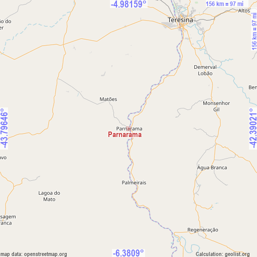
Parnarama GPS coordinates[2]
5° 40' 54.012" South, 43° 5' 35.988" West
| Map corner | latitude | longitude |
|---|---|---|
| Upper-left | -4.98159°, | -43.79646° |
| Center: | -5.68167°, | -43.09333° |
| Lower-right: | -6.3809°, | -42.39021° |
| Map W x H: | 155.6×155.6 km | = 96.7×96.7mi |
| max Lat: | 2.81972° ⇑13.6% North |
| Parnarama: | -5.68167° |
| min Lat: | ⇓86.4% South -33.69111° |
| min Long | Parnarama | max Long |
| -72.89583° | -43.09333° | -32.41083° |
| W 59.8%⇐ | ⇒40.2% E |
Elevation
Elevation of Parnarama is 87 m = 285 ft, and this is 293.9 m = 964 ft below average elevation for this country.
| Max E: |
1603 m = 5259 ft | 74.3% |
| Avg. | 380.9 m = 1250 ft | |
| Parnarama | 87 m = 285 ft | |
Min E: |
0 m = 0 ft | 25.7% |
See also: Brazil elevation on elevation.city.
Geographical zone
Parnarama is located in South Torrid zone (between Equator and Tropic of Capricorn). Distance of Equator is 631.7 km =392.5 mi to North.| Distance of | km | miles | from Parnarama |
|---|---|---|---|
| Equator | 631.7 | 392.5 | to North |
| Tropic Capricorn | 1974.2 | 1226.7 | to South |
| Antarctic Circle | 6769.4 | 4206.3 | to South |
| South Pole | 9375.3 | 5825.5 | to South |


Nearby cities:
15 places around Parnarama: (largest is in red/bold)
• Altos
100.2 km =62.3 mi,  44°
44°
• Amarante
68.2 km =42.4 mi,  156°
156°
• Beneditinos
84.4 km =52.4 mi,  72°
72°
• Buriti Bravo
83.7 km =52 mi,  258°
258°
• Caxias
96 km =59.7 mi,  342°
342°
• Demerval Lobão
58.5 km =36.4 mi,  52°
52°
• Estreito
20.7 km =12.9 mi,  236°
236°
• Monsenhor Gil
55.3 km =34.4 mi,  76°
76°
• Palmeirais
33.1 km =20.6 mi,  174°
174°
• Passagem Franca
94.3 km =58.6 mi,  234°
234°
• Regeneração
75.9 km =47.2 mi,  143°
143°
• São Pedro do Piauí
49.8 km =30.9 mi,  123°
123°
• Teresina
73.4 km =45.6 mi,  26°
26°
• Timon
71.2 km =44.2 mi,  23°
23°
• Água Branca
55.7 km =34.6 mi,  114°
114°
Sources, notices
• [Note1] Compared only with cities in Brazil existing in our database
• [Src1] Map data: © OpenStreetMap contributors (CC-BY-SA)
• [Src2] Other city data from geonames.org with taken over terms of usage.
• [Src3] Geographical zone / Annual Mean Temperature by Robert A. Rohde @ Wikipedia
