Altinho geodata
Altinho (Pernambuco) is a populated place; located in Brazil in America/Recife (GMT-3) time zone. With population of 11,913 people, there are 1485 cities with bigger population in this country. Compared to other cities in Brazil, 73.1% of cities are located further ↓South; 92.4% of cities are located further ←West and 58.3% of cities have lower elevation than Altinho. Note1


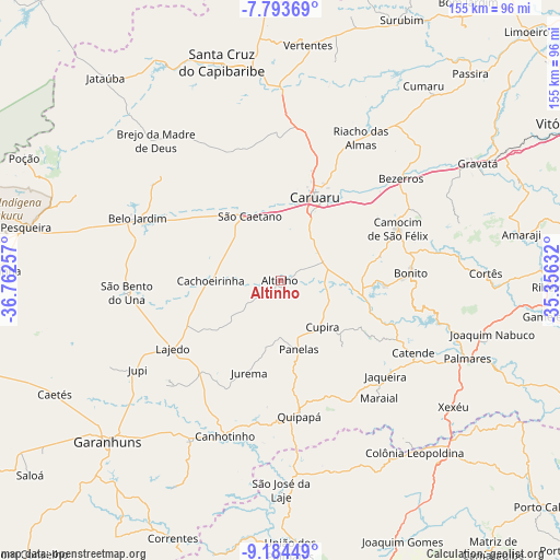
Altinho GPS coordinates[2]
8° 29' 22.992" South, 36° 3' 33.984" West
| Map corner | latitude | longitude |
|---|---|---|
| Upper-left | -7.79369°, | -36.76257° |
| Center: | -8.48972°, | -36.05944° |
| Lower-right: | -9.18449°, | -35.35632° |
| Map W x H: | 154.6×154.6 km | = 96.1×96.1mi |
| max Lat: | 2.81972° ⇑26.9% North |
| Altinho: | -8.48972° |
| min Lat: | ⇓73.1% South -33.69111° |
| min Long | Altinho | max Long |
| -72.89583° | -36.05944° | -32.41083° |
| W 92.4%⇐ | ⇒7.6% E |
Elevation
Elevation of Altinho is 458 m = 1503 ft, and this is 77.1 m = 253 ft above average elevation for this country.
| Max E: |
1603 m = 5259 ft | 41.7% |
| Altinho | 458 m 1503 ft | |
| Avg. | 380.9 m = 1250 ft | |
Min E: |
0 m = 0 ft | 58.3% |
See also: Brazil elevation on elevation.city.
Geographical zone
Altinho is located in South Torrid zone (between Equator and Tropic of Capricorn). Distance of Equator is 944 km =586.6 mi to North.| Distance of | km | miles | from Altinho |
|---|---|---|---|
| Equator | 944 | 586.6 | to North |
| Tropic Capricorn | 1662 | 1032.7 | to South |
| Antarctic Circle | 6457.2 | 4012.3 | to South |
| South Pole | 9063.1 | 5631.5 | to South |


Nearby cities:
15 places around Altinho: (largest is in red/bold)
• Agrestina
13.1 km =8.1 mi,  74°
74°
• Belo Jardim
43.6 km =27.1 mi,  293°
293°
• Bezerros
40.6 km =25.2 mi,  45°
45°
• Bonito
36.4 km =22.6 mi,  86°
86°
• Cachoeirinha
19.1 km =11.9 mi,  271°
271°
• Camocim de São Félix
35.8 km =22.2 mi, 65°
• Canhotinho
46 km =28.6 mi,  198°
198°
• Caruaru
24.7 km =15.3 mi,  21°
21°
• Catende
42.5 km =26.4 mi,  117°
117°
• Cupira
18.5 km =11.5 mi,  139°
139°
• Guabiraba
44 km =27.3 mi,  79°
79°
• Lajedo
34.6 km =21.5 mi,  235°
235°
• Maraial
42.6 km =26.5 mi, 139°
• Quipapá
38 km =23.6 mi,  172°
172°
• São Joaquim do Monte
28.8 km =17.9 mi, 77°
Sources, notices
• [Note1] Compared only with cities in Brazil existing in our database
• [Src1] Map data: © OpenStreetMap contributors (CC-BY-SA)
• [Src2] Other city data from geonames.org with taken over terms of usage.
• [Src3] Geographical zone / Annual Mean Temperature by Robert A. Rohde @ Wikipedia
