Lajedo geodata
Lajedo (Pernambuco) is a populated place; located in Brazil in America/Recife (GMT-3) time zone. With population of 25,261 people, there are 778 cities with bigger population in this country. Compared to other cities in Brazil, 72.6% of cities are located further ↓South; 91.6% of cities are located further ←West and 78.5% of cities have lower elevation than Lajedo. Note1


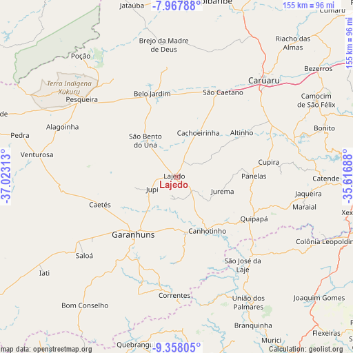
Lajedo GPS coordinates[2]
8° 39' 48.996" South, 36° 19' 12" West
| Map corner | latitude | longitude |
|---|---|---|
| Upper-left | -7.96788°, | -37.02313° |
| Center: | -8.66361°, | -36.32° |
| Lower-right: | -9.35805°, | -35.61688° |
| Map W x H: | 154.6×154.6 km | = 96.1×96.1mi |
| max Lat: | 2.81972° ⇑27.4% North |
| Lajedo: | -8.66361° |
| min Lat: | ⇓72.6% South -33.69111° |
| min Long | Lajedo | max Long |
| -72.89583° | -36.32° | -32.41083° |
| W 91.6%⇐ | ⇒8.4% E |
Elevation
Elevation of Lajedo is 672 m = 2205 ft, and this is 291.1 m = 955 ft above average elevation for this country.
| Max E: |
1603 m = 5259 ft | 21.5% |
| Lajedo | 672 m 2205 ft | |
| Avg. | 380.9 m = 1250 ft | |
Min E: |
0 m = 0 ft | 78.5% |
See also: Brazil elevation on elevation.city.
Geographical zone
Lajedo is located in South Torrid zone (between Equator and Tropic of Capricorn). Distance of Equator is 963.3 km =598.6 mi to North.| Distance of | km | miles | from Lajedo |
|---|---|---|---|
| Equator | 963.3 | 598.6 | to North |
| Tropic Capricorn | 1642.6 | 1020.7 | to South |
| Antarctic Circle | 6437.9 | 4000.3 | to South |
| South Pole | 9043.8 | 5619.6 | to South |


Nearby cities:
15 places around Lajedo: (largest is in red/bold)
• Agrestina
47.2 km =29.3 mi,  61°
61°
• Altinho
34.6 km =21.5 mi, 55°
• Belo Jardim
38.2 km =23.7 mi,  342°
342°
• Cachoeirinha
21.9 km =13.6 mi,  25°
25°
• Caetés
35.4 km =22 mi,  249°
249°
• Canhotinho
28.1 km =17.5 mi,  149°
149°
• Capoeiras
34.6 km =21.5 mi,  256°
256°
• Caruaru
56.7 km =35.2 mi,  41°
41°
• Cupira
41 km =25.5 mi,  82°
82°
• Garanhuns
31.5 km =19.6 mi,  219°
219°
• Ibateguara
54.1 km =33.6 mi,  129°
129°
• Pesqueira
53.6 km =33.3 mi,  309°
309°
• Quipapá
38.5 km =23.9 mi,  118°
118°
• São José da Laje
48 km =29.8 mi,  143°
143°
• São João
24.1 km =15 mi,  192°
192°
Sources, notices
• [Note1] Compared only with cities in Brazil existing in our database
• [Src1] Map data: © OpenStreetMap contributors (CC-BY-SA)
• [Src2] Other city data from geonames.org with taken over terms of usage.
• [Src3] Geographical zone / Annual Mean Temperature by Robert A. Rohde @ Wikipedia
