Alexandria geodata
Alexandria (Rio Grande do Norte) is a populated place; located in Brazil in America/Fortaleza (GMT-3) time zone. With population of 9,769 people, there are 1666 cities with bigger population in this country. Compared to other cities in Brazil, 83.4% of cities are located further ↓South; 84.2% of cities are located further ←West and 52.5% of cities have higher elevation than Alexandria. Note1


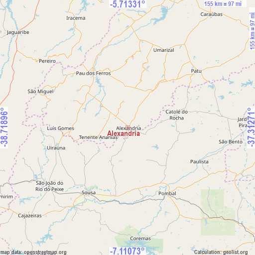
Alexandria GPS coordinates[2]
6° 24' 45" South, 38° 0' 56.988" West
| Map corner | latitude | longitude |
|---|---|---|
| Upper-left | -5.71331°, | -38.71896° |
| Center: | -6.4125°, | -38.01583° |
| Lower-right: | -7.11073°, | -37.31271° |
| Map W x H: | 155.4×155.4 km | = 96.6×96.6mi |
| max Lat: | 2.81972° ⇑16.6% North |
| Alexandria: | -6.4125° |
| min Lat: | ⇓83.4% South -33.69111° |
| min Long | Alexandria | max Long |
| -72.89583° | -38.01583° | -32.41083° |
| W 84.2%⇐ | ⇒15.8% E |
Elevation
Elevation of Alexandria is 314 m = 1030 ft, and this is 66.9 m = 219 ft below average elevation for this country.
| Max E: |
1603 m = 5259 ft | 52.5% |
| Avg. | 380.9 m = 1250 ft | |
| Alexandria | 314 m = 1030 ft | |
Min E: |
0 m = 0 ft | 47.5% |
See also: Brazil elevation on elevation.city.
Geographical zone
Alexandria is located in South Torrid zone (between Equator and Tropic of Capricorn). Distance of Equator is 713 km =443 mi to North.| Distance of | km | miles | from Alexandria |
|---|---|---|---|
| Equator | 713 | 443 | to North |
| Tropic Capricorn | 1892.9 | 1176.2 | to South |
| Antarctic Circle | 6688.2 | 4155.9 | to South |
| South Pole | 9294.1 | 5775.1 | to South |


Nearby cities:
15 places around Alexandria: (largest is in red/bold)
• Belém do Brejo do Cruz
58.6 km =36.4 mi,  64°
64°
• Catolé do Rocha
30.7 km =19.1 mi,  75°
75°
• Coremas
67.4 km =41.9 mi,  173°
173°
• Jardim de Piranhas
73.5 km =45.7 mi,  87°
87°
• Juàzeirinho
45.1 km =28 mi,  184°
184°
• Patu
53.7 km =33.4 mi,  51°
51°
• Paulista
47.7 km =29.6 mi,  114°
114°
• Pombal
46.3 km =28.8 mi,  149°
149°
• Serra Branca
30.8 km =19.1 mi,  244°
244°
• Severiano Melo
70.9 km =44.1 mi,  5°
5°
• Sousa
45.1 km =28 mi,  211°
211°
• São Bento
32.7 km =20.3 mi, 63°
• Triunfo
66.8 km =41.5 mi,  255°
255°
• Uiraúna
45.3 km =28.1 mi,  254°
254°
• Umarizal
51.9 km =32.2 mi,  25°
25°
Sources, notices
• [Note1] Compared only with cities in Brazil existing in our database
• [Src1] Map data: © OpenStreetMap contributors (CC-BY-SA)
• [Src2] Other city data from geonames.org with taken over terms of usage.
• [Src3] Geographical zone / Annual Mean Temperature by Robert A. Rohde @ Wikipedia
