Sousa geodata
Sousa (Paraíba) is a populated place; located in Brazil in America/Fortaleza (GMT-3) time zone. With population of 47,927 people, there are 447 cities with bigger population in this country. Compared to other cities in Brazil, 81.7% of cities are located further ↓South; 83.7% of cities are located further ←West and 58.4% of cities have higher elevation than Sousa. Note1


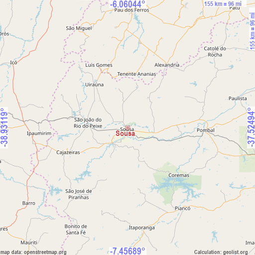
Sousa GPS coordinates[2]
6° 45' 33.012" South, 38° 13' 41.016" West
| Map corner | latitude | longitude |
|---|---|---|
| Upper-left | -6.06044°, | -38.93119° |
| Center: | -6.75917°, | -38.22806° |
| Lower-right: | -7.45689°, | -37.52494° |
| Map W x H: | 155.3×155.3 km | = 96.5×96.5mi |
| max Lat: | 2.81972° ⇑18.3% North |
| Sousa: | -6.75917° |
| min Lat: | ⇓81.7% South -33.69111° |
| min Long | Sousa | max Long |
| -72.89583° | -38.22806° | -32.41083° |
| W 83.7%⇐ | ⇒16.3% E |
Elevation
Elevation of Sousa is 229 m = 751 ft, and this is 151.9 m = 498 ft below average elevation for this country.
| Max E: |
1603 m = 5259 ft | 58.4% |
| Avg. | 380.9 m = 1250 ft | |
| Sousa | 229 m = 751 ft | |
Min E: |
0 m = 0 ft | 41.6% |
See also: Sousa elevation on elevation.city.
Geographical zone
Sousa is located in South Torrid zone (between Equator and Tropic of Capricorn). Distance of Equator is 751.5 km =467 mi to North.| Distance of | km | miles | from Sousa |
|---|---|---|---|
| Equator | 751.5 | 467 | to North |
| Tropic Capricorn | 1854.4 | 1152.3 | to South |
| Antarctic Circle | 6649.6 | 4131.9 | to South |
| South Pole | 9255.5 | 5751.1 | to South |


Nearby cities:
15 places around Sousa: (largest is in red/bold)
• Alexandria
45.1 km =28 mi,  31°
31°
• Barro
70.7 km =43.9 mi,  273°
273°
• Cajazeiras
39 km =24.2 mi,  248°
248°
• Catolé do Rocha
70.4 km =43.7 mi,  49°
49°
• Coremas
42.1 km =26.2 mi,  132°
132°
• Itaporanga
61.2 km =38 mi,  171°
171°
• Juàzeirinho
20.7 km =12.9 mi,  108°
108°
• Paulista
69.2 km =43 mi,  74°
74°
• Piancó
58.9 km =36.6 mi,  145°
145°
• Pombal
47.1 km =29.3 mi,  91°
91°
• Serra Branca
25.5 km =15.8 mi,  350°
350°
• São Bento
74.8 km =46.5 mi,  44°
44°
• São José de Piranhas
50.3 km =31.3 mi,  216°
216°
• Triunfo
46.3 km =28.8 mi,  297°
297°
• Uiraúna
33.6 km =20.9 mi,  322°
322°
Sources, notices
• [Note1] Compared only with cities in Brazil existing in our database
• [Src1] Map data: © OpenStreetMap contributors (CC-BY-SA)
• [Src2] Other city data from geonames.org with taken over terms of usage.
• [Src3] Geographical zone / Annual Mean Temperature by Robert A. Rohde @ Wikipedia
