Serra Branca geodata
Serra Branca (Paraíba) is a populated place; located in Brazil in America/Fortaleza (GMT-3) time zone. With population of 8,765 people, there are 1737 cities with bigger population in this country. Compared to other cities in Brazil, 82.8% of cities are located further ↓South; 83.6% of cities are located further ←West and 51.9% of cities have higher elevation than Serra Branca. Note1


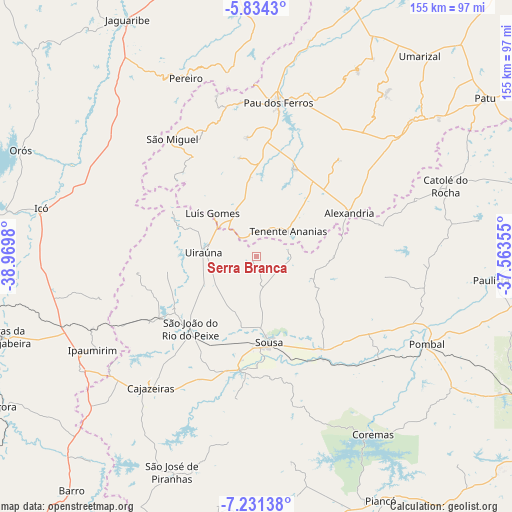
Serra Branca GPS coordinates[2]
6° 31' 59.988" South, 38° 16' 0.012" West
| Map corner | latitude | longitude |
|---|---|---|
| Upper-left | -5.8343°, | -38.9698° |
| Center: | -6.53333°, | -38.26667° |
| Lower-right: | -7.23138°, | -37.56355° |
| Map W x H: | 155.3×155.3 km | = 96.5×96.5mi |
| max Lat: | 2.81972° ⇑17.2% North |
| Serra Branca: | -6.53333° |
| min Lat: | ⇓82.8% South -33.69111° |
| min Long | Serra Branca | max Long |
| -72.89583° | -38.26667° | -32.41083° |
| W 83.6%⇐ | ⇒16.4% E |
Elevation
Elevation of Serra Branca is 327 m = 1073 ft, and this is 53.9 m = 177 ft below average elevation for this country.
| Max E: |
1603 m = 5259 ft | 51.9% |
| Avg. | 380.9 m = 1250 ft | |
| Serra Branca | 327 m = 1073 ft | |
Min E: |
0 m = 0 ft | 48.1% |
See also: Brazil elevation on elevation.city.
Geographical zone
Serra Branca is located in South Torrid zone (between Equator and Tropic of Capricorn). Distance of Equator is 726.4 km =451.4 mi to North.| Distance of | km | miles | from Serra Branca |
|---|---|---|---|
| Equator | 726.4 | 451.4 | to North |
| Tropic Capricorn | 1879.5 | 1167.9 | to South |
| Antarctic Circle | 6674.7 | 4147.5 | to South |
| South Pole | 9280.6 | 5766.7 | to South |


Nearby cities:
15 places around Serra Branca: (largest is in red/bold)
• Alexandria
30.8 km =19.1 mi,  64°
64°
• Barro
69.3 km =43.1 mi,  252°
252°
• Cajazeiras
50.9 km =31.6 mi,  218°
218°
• Catolé do Rocha
61.2 km =38 mi,  69°
69°
• Coremas
64.2 km =39.9 mi,  146°
146°
• Icó
67.4 km =41.9 mi,  282°
282°
• Juàzeirinho
39.6 km =24.6 mi,  142°
142°
• Paulista
71.3 km =44.3 mi,  95°
95°
• Pombal
57.7 km =35.9 mi,  117°
117°
• Sousa
25.5 km =15.8 mi,  170°
170°
• São Bento
63.5 km =39.5 mi, 64°
• São José de Piranhas
70.3 km =43.7 mi,  201°
201°
• Triunfo
37 km =23 mi,  264°
264°
• Uiraúna
16.2 km =10.1 mi, 275°
• Umarizal
78.4 km =48.7 mi,  39°
39°
Sources, notices
• [Note1] Compared only with cities in Brazil existing in our database
• [Src1] Map data: © OpenStreetMap contributors (CC-BY-SA)
• [Src2] Other city data from geonames.org with taken over terms of usage.
• [Src3] Geographical zone / Annual Mean Temperature by Robert A. Rohde @ Wikipedia
