Umarizal geodata
Umarizal (Rio Grande do Norte) is a populated place; located in Brazil in America/Fortaleza (GMT-3) time zone. With population of 8,780 people, there are 1734 cities with bigger population in this country. Compared to other cities in Brazil, 85.3% of cities are located further ↓South; 85.1% of cities are located further ←West and 64.1% of cities have higher elevation than Umarizal. Note1


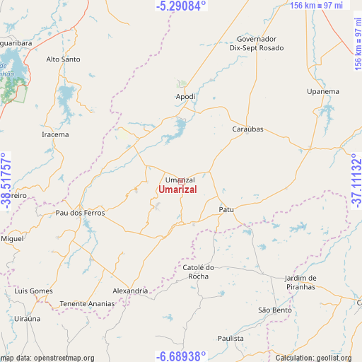
Umarizal GPS coordinates[2]
5° 59' 26.016" South, 37° 48' 51.984" West
| Map corner | latitude | longitude |
|---|---|---|
| Upper-left | -5.29084°, | -38.51757° |
| Center: | -5.99056°, | -37.81444° |
| Lower-right: | -6.68938°, | -37.11132° |
| Map W x H: | 155.5×155.5 km | = 96.6×96.6mi |
| max Lat: | 2.81972° ⇑14.7% North |
| Umarizal: | -5.99056° |
| min Lat: | ⇓85.3% South -33.69111° |
| min Long | Umarizal | max Long |
| -72.89583° | -37.81444° | -32.41083° |
| W 85.1%⇐ | ⇒14.9% E |
Elevation
Elevation of Umarizal is 174 m = 571 ft, and this is 206.9 m = 679 ft below average elevation for this country.
| Max E: |
1603 m = 5259 ft | 64.1% |
| Avg. | 380.9 m = 1250 ft | |
| Umarizal | 174 m = 571 ft | |
Min E: |
0 m = 0 ft | 35.9% |
See also: Brazil elevation on elevation.city.
Geographical zone
Umarizal is located in South Torrid zone (between Equator and Tropic of Capricorn). Distance of Equator is 666.1 km =413.9 mi to North.| Distance of | km | miles | from Umarizal |
|---|---|---|---|
| Equator | 666.1 | 413.9 | to North |
| Tropic Capricorn | 1939.8 | 1205.3 | to South |
| Antarctic Circle | 6735.1 | 4185 | to South |
| South Pole | 9341 | 5804.2 | to South |


Nearby cities:
15 places around Umarizal: (largest is in red/bold)
• Alexandria
51.9 km =32.2 mi,  205°
205°
• Apodi
36.3 km =22.6 mi,  2°
2°
• Belém do Brejo do Cruz
37.9 km =23.5 mi,  125°
125°
• Caraúbas
36 km =22.4 mi,  52°
52°
• Catolé do Rocha
40 km =24.9 mi,  169°
169°
• Governador Dix Sept Rosado
67.5 km =41.9 mi,  28°
28°
• Jardim de Piranhas
66.9 km =41.6 mi, 130°
• Jucurutu
87.9 km =54.6 mi,  93°
93°
• Patu
23.7 km =14.7 mi,  124°
124°
• Paulista
70.3 km =43.7 mi,  162°
162°
• Pombal
86.7 km =53.9 mi,  179°
179°
• Serra Branca
78.4 km =48.7 mi,  219°
219°
• Severiano Melo
28.5 km =17.7 mi,  326°
326°
• São Bento
33.3 km =20.7 mi, 167°
• Upanema
72.8 km =45.2 mi,  57°
57°
Sources, notices
• [Note1] Compared only with cities in Brazil existing in our database
• [Src1] Map data: © OpenStreetMap contributors (CC-BY-SA)
• [Src2] Other city data from geonames.org with taken over terms of usage.
• [Src3] Geographical zone / Annual Mean Temperature by Robert A. Rohde @ Wikipedia
