Açu geodata
Açu (Rio Grande do Norte) is a populated place; located in Brazil in America/Fortaleza (GMT-3) time zone. With population of 36,125 people, there are 568 cities with bigger population in this country. Compared to other cities in Brazil, 86.8% of cities are located further ↓South; 89.3% of cities are located further ←West and 83% of cities have higher elevation than Açu. Note1


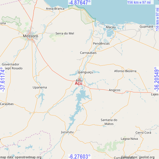
Açu GPS coordinates[2]
5° 34' 36.012" South, 36° 54' 30.996" West
| Map corner | latitude | longitude |
|---|---|---|
| Upper-left | -4.87647°, | -37.61174° |
| Center: | -5.57667°, | -36.90861° |
| Lower-right: | -6.27603°, | -36.20549° |
| Map W x H: | 155.6×155.6 km | = 96.7×96.7mi |
| max Lat: | 2.81972° ⇑13.2% North |
| Açu: | -5.57667° |
| min Lat: | ⇓86.8% South -33.69111° |
| min Long | Açu | max Long |
| -72.89583° | -36.90861° | -32.41083° |
| W 89.3%⇐ | ⇒10.7% E |
Elevation
Elevation of Açu is 36 m = 118 ft, and this is 344.9 m = 1132 ft below average elevation for this country.
| Max E: |
1603 m = 5259 ft | 83% |
| Avg. | 380.9 m = 1250 ft | |
| Açu | 36 m = 118 ft | |
Min E: |
0 m = 0 ft | 17% |
See also: Brazil elevation on elevation.city.
Geographical zone
Açu is located in South Torrid zone (between Equator and Tropic of Capricorn). Distance of Equator is 620.1 km =385.3 mi to North.| Distance of | km | miles | from Açu |
|---|---|---|---|
| Equator | 620.1 | 385.3 | to North |
| Tropic Capricorn | 1985.9 | 1234 | to South |
| Antarctic Circle | 6781.1 | 4213.6 | to South |
| South Pole | 9387 | 5832.8 | to South |


Nearby cities:
15 places around Açu: (largest is in red/bold)
• Afonso Bezerra
45.4 km =28.2 mi,  78°
78°
• Angicos
35.4 km =22 mi,  106°
106°
• Areia Branca
73.5 km =45.7 mi,  339°
339°
• Caraúbas
75.6 km =47 mi,  251°
251°
• Cerro Corá
81.2 km =50.5 mi,  129°
129°
• Governador Dix Sept Rosado
69 km =42.9 mi,  280°
280°
• Ipanguaçu
10.5 km =6.5 mi,  34°
34°
• Jucurutu
52.3 km =32.5 mi,  193°
193°
• Lagoa Nova
74.8 km =46.5 mi,  141°
141°
• Macau
59.6 km =37 mi, 30°
• Monte Alegre
75.7 km =47 mi,  117°
117°
• Mossoró
64.8 km =40.3 mi,  311°
311°
• Pendências
40.8 km =25.4 mi, 30°
• Santana do Matos
50.8 km =31.6 mi,  146°
146°
• Upanema
39.3 km =24.4 mi,  259°
259°
Sources, notices
• [Note1] Compared only with cities in Brazil existing in our database
• [Src1] Map data: © OpenStreetMap contributors (CC-BY-SA)
• [Src2] Other city data from geonames.org with taken over terms of usage.
• [Src3] Geographical zone / Annual Mean Temperature by Robert A. Rohde @ Wikipedia
