Upanema geodata
Upanema (Rio Grande do Norte) is a populated place; located in Brazil in America/Fortaleza (GMT-3) time zone. With population of 6,704 people, there are 1845 cities with bigger population in this country. Compared to other cities in Brazil, 86.5% of cities are located further ↓South; 87.8% of cities are located further ←West and 80.1% of cities have higher elevation than Upanema. Note1


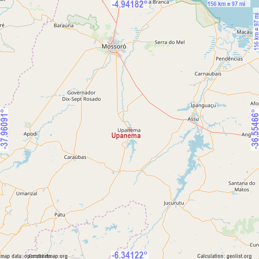
Upanema GPS coordinates[2]
5° 38' 30.984" South, 37° 15' 28.008" West
| Map corner | latitude | longitude |
|---|---|---|
| Upper-left | -4.94182°, | -37.96091° |
| Center: | -5.64194°, | -37.25778° |
| Lower-right: | -6.34122°, | -36.55466° |
| Map W x H: | 155.6×155.6 km | = 96.7×96.7mi |
| max Lat: | 2.81972° ⇑13.5% North |
| Upanema: | -5.64194° |
| min Lat: | ⇓86.5% South -33.69111° |
| min Long | Upanema | max Long |
| -72.89583° | -37.25778° | -32.41083° |
| W 87.8%⇐ | ⇒12.2% E |
Elevation
Elevation of Upanema is 46 m = 151 ft, and this is 334.9 m = 1099 ft below average elevation for this country.
| Max E: |
1603 m = 5259 ft | 80.1% |
| Avg. | 380.9 m = 1250 ft | |
| Upanema | 46 m = 151 ft | |
Min E: |
0 m = 0 ft | 19.9% |
See also: Brazil elevation on elevation.city.
Geographical zone
Upanema is located in South Torrid zone (between Equator and Tropic of Capricorn). Distance of Equator is 627.3 km =389.8 mi to North.| Distance of | km | miles | from Upanema |
|---|---|---|---|
| Equator | 627.3 | 389.8 | to North |
| Tropic Capricorn | 1978.6 | 1229.4 | to South |
| Antarctic Circle | 6773.8 | 4209 | to South |
| South Pole | 9379.7 | 5828.3 | to South |


Nearby cities:
15 places around Upanema: (largest is in red/bold)
• Angicos
72.7 km =45.2 mi,  92°
92°
• Apodi
59.9 km =37.2 mi,  267°
267°
• Areia Branca
77.4 km =48.1 mi,  9°
9°
• Açu
39.3 km =24.4 mi,  79°
79°
• Baraúna
74 km =46 mi,  327°
327°
• Belém do Brejo do Cruz
68.1 km =42.3 mi,  206°
206°
• Caraúbas
37.1 km =23.1 mi,  243°
243°
• Governador Dix Sept Rosado
35.5 km =22.1 mi,  304°
304°
• Ipanguaçu
47.3 km =29.4 mi,  70°
70°
• Jucurutu
50.9 km =31.6 mi,  148°
148°
• Mossoró
51.4 km =31.9 mi,  349°
349°
• Patu
66.8 km =41.5 mi,  218°
218°
• Pendências
72.9 km =45.3 mi,  54°
54°
• Santana do Matos
75.3 km =46.8 mi,  117°
117°
• Umarizal
72.8 km =45.2 mi, 237°
Sources, notices
• [Note1] Compared only with cities in Brazil existing in our database
• [Src1] Map data: © OpenStreetMap contributors (CC-BY-SA)
• [Src2] Other city data from geonames.org with taken over terms of usage.
• [Src3] Geographical zone / Annual Mean Temperature by Robert A. Rohde @ Wikipedia
