Caraúbas geodata
Caraúbas (Rio Grande do Norte) is a populated place; located in Brazil in America/Fortaleza (GMT-3) time zone. With population of 12,462 people, there are 1427 cities with bigger population in this country. Compared to other cities in Brazil, 86.1% of cities are located further ↓South; 86.5% of cities are located further ←West and 66.9% of cities have higher elevation than Caraúbas. Note1


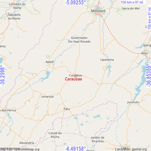
Caraúbas GPS coordinates[2]
5° 47' 33" South, 37° 33' 24.012" West
| Map corner | latitude | longitude |
|---|---|---|
| Upper-left | -5.09255°, | -38.2598° |
| Center: | -5.7925°, | -37.55667° |
| Lower-right: | -6.49158°, | -36.85355° |
| Map W x H: | 155.6×155.6 km | = 96.7×96.7mi |
| max Lat: | 2.81972° ⇑13.9% North |
| Caraúbas: | -5.7925° |
| min Lat: | ⇓86.1% South -33.69111° |
| min Long | Caraúbas | max Long |
| -72.89583° | -37.55667° | -32.41083° |
| W 86.5%⇐ | ⇒13.5% E |
Elevation
Elevation of Caraúbas is 152 m = 499 ft, and this is 228.9 m = 751 ft below average elevation for this country.
| Max E: |
1603 m = 5259 ft | 66.9% |
| Avg. | 380.9 m = 1250 ft | |
| Caraúbas | 152 m = 499 ft | |
Min E: |
0 m = 0 ft | 33.1% |
See also: Brazil elevation on elevation.city.
Geographical zone
Caraúbas is located in South Torrid zone (between Equator and Tropic of Capricorn). Distance of Equator is 644.1 km =400.2 mi to North.| Distance of | km | miles | from Caraúbas |
|---|---|---|---|
| Equator | 644.1 | 400.2 | to North |
| Tropic Capricorn | 1961.9 | 1219.1 | to South |
| Antarctic Circle | 6757.1 | 4198.7 | to South |
| South Pole | 9363 | 5817.9 | to South |


Nearby cities:
15 places around Caraúbas: (largest is in red/bold)
• Apodi
30.4 km =18.9 mi,  298°
298°
• Açu
75.6 km =47 mi,  71°
71°
• Baraúna
79.5 km =49.4 mi,  355°
355°
• Belém do Brejo do Cruz
44.1 km =27.4 mi,  177°
177°
• Catolé do Rocha
64.8 km =40.3 mi,  198°
198°
• Governador Dix Sept Rosado
37.3 km =23.2 mi,  6°
6°
• Ipanguaçu
84.2 km =52.3 mi, 67°
• Jardim de Piranhas
69 km =42.9 mi,  160°
160°
• Jucurutu
65.1 km =40.5 mi,  114°
114°
• Mossoró
71.3 km =44.3 mi,  19°
19°
• Patu
36.4 km =22.6 mi,  194°
194°
• Severiano Melo
44.4 km =27.6 mi,  272°
272°
• São Bento
58.6 km =36.4 mi, 201°
• Umarizal
36 km =22.4 mi,  232°
232°
• Upanema
37.1 km =23.1 mi,  63°
63°
Sources, notices
• [Note1] Compared only with cities in Brazil existing in our database
• [Src1] Map data: © OpenStreetMap contributors (CC-BY-SA)
• [Src2] Other city data from geonames.org with taken over terms of usage.
• [Src3] Geographical zone / Annual Mean Temperature by Robert A. Rohde @ Wikipedia
