Governador Dix Sept Rosado geodata
Governador Dix Sept Rosado (Rio Grande do Norte) is a populated place; located in Brazil in America/Fortaleza (GMT-3) time zone. With population of 6,626 people, there are 1848 cities with bigger population in this country. Compared to other cities in Brazil, 87.4% of cities are located further ↓South; 86.7% of cities are located further ←West and 83.5% of cities have higher elevation than Governador Dix Sept Rosado. Note1
Current local time in Governador Dix Sept Rosado:
05:15 PM, TuesdayDifference from your time zone: hours


Governador Dix Sept Rosado GPS coordinates[2]
5° 27' 32.004" South, 37° 31' 14.988" West
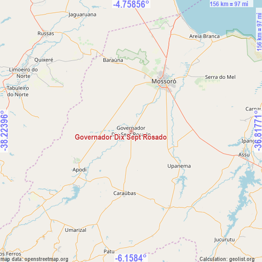
| Map corner | latitude | longitude |
|---|---|---|
| Upper-left | -4.75856°, | -38.22396° |
| Center: | -5.45889°, | -37.52083° |
| Lower-right: | -6.1584°, | -36.81771° |
| Map W x H: | 155.6×155.7 km | = 96.7×96.7mi |
| max Lat: | 2.81972° ⇑12.6% North |
| Governador Dix Sept Rosado: | -5.45889° |
| min Lat: | ⇓87.4% South -33.69111° |
| min Long | Governador Dix | max Long |
| -72.89583° | -37.52083° | -32.41083° |
| W 86.7%⇐ | ⇒13.3% E |
Elevation
Elevation of Governador Dix Sept Rosado is 35 m = 115 ft, and this is 345.9 m = 1135 ft below average elevation for this country.
| Max E: |
1603 m = 5259 ft | 83.5% |
| Avg. | 380.9 m = 1250 ft | |
| Governador Dix Sept Rosado | 35 m = 115 ft | |
Min E: |
0 m = 0 ft | 16.5% |
See also: Brazil elevation on elevation.city.
Geographical zone
Governador Dix Sept Rosado is located in South Torrid zone (between Equator and Tropic of Capricorn). Distance of Equator is 607 km =377.2 mi to North.| Distance of | km | miles | from Governador Dix Sept Rosado |
|---|---|---|---|
| Equator | 607 | 377.2 | to North |
| Tropic Capricorn | 1998.9 | 1242.1 | to South |
| Antarctic Circle | 6794.2 | 4221.7 | to South |
| South Pole | 9400.1 | 5840.9 | to South |


Nearby cities:
15 places around Governador Dix Sept Rosado: (largest is in red/bold)
• Apodi
38.3 km =23.8 mi,  233°
233°
• Areia Branca
70.2 km =43.6 mi,  37°
37°
• Açu
69 km =42.9 mi,  100°
100°
• Baraúna
43.4 km =27 mi,  345°
345°
• Caraúbas
37.3 km =23.2 mi,  186°
186°
• Ipanguaçu
73.8 km =45.9 mi,  93°
93°
• Jaguaruana
75.2 km =46.7 mi,  337°
337°
• Limoeiro do Norte
72.8 km =45.2 mi,  298°
298°
• Mossoró
36 km =22.4 mi,  32°
32°
• Patu
73.5 km =45.7 mi, 190°
• Quixeré
67.2 km =41.8 mi,  309°
309°
• Russas
76.6 km =47.6 mi,  318°
318°
• Severiano Melo
59.9 km =37.2 mi, 233°
• Umarizal
67.5 km =41.9 mi,  208°
208°
• Upanema
35.5 km =22.1 mi,  124°
124°
Sources, notices
• [Note1] Compared only with cities in Brazil existing in our database
• [Src1] Map data: © OpenStreetMap contributors (CC-BY-SA)
• [Src2] Other city data from geonames.org with taken over terms of usage.
• [Src3] Geographical zone / Annual Mean Temperature by Robert A. Rohde @ Wikipedia
