Torres geodata
Torres (Rio Grande do Sul) is a populated place; located in Brazil in America/Sao_Paulo (GMT-3) time zone. With population of 32,791 people, there are 623 cities with bigger population in this country. Compared to other cities in Brazil, 96.5% of cities are located further ↑North; 77.1% of cities are located further →East and 96.1% of cities have higher elevation than Torres. Note1


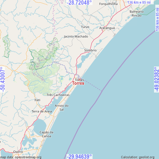
Torres GPS coordinates[2]
29° 20' 7.008" South, 49° 43' 36.984" West
| Map corner | latitude | longitude |
|---|---|---|
| Upper-left | -28.72048°, | -50.43007° |
| Center: | -29.33528°, | -49.72694° |
| Lower-right: | -29.94639°, | -49.02382° |
| Map W x H: | 136.3×136.3 km | = 84.7×84.7mi |
| max Lat: | 2.81972° ⇑96.5% North |
| Torres: | -29.33528° |
| min Lat: | ⇓3.5% South -33.69111° |
| min Long | Torres | max Long |
| -72.89583° | -49.72694° | -32.41083° |
| W 22.9%⇐ | ⇒77.1% E |
Elevation
Elevation of Torres is 8 m = 26 ft, and this is 372.9 m = 1223 ft below average elevation for this country.
| Max E: |
1603 m = 5259 ft | 96.1% |
| Avg. | 380.9 m = 1250 ft | |
| Torres | 8 m = 26 ft | |
Min E: |
0 m = 0 ft | 3.9% |
See also: Brazil elevation on elevation.city.
Geographical zone
Torres is located in South temperate zone (between Tropic of Capricorn and the Antarctic Circle). Distance of this Southern Tropic circle is 655.9 km =407.6 mi to North.| Distance of | km | miles | from Torres |
|---|---|---|---|
| Equator | 3261.8 | 2026.8 | to North |
| Tropic Capricorn | 655.9 | 407.6 | to North |
| Antarctic Circle | 4139.4 | 2572.1 | to South |
| South Pole | 6745.3 | 4191.3 | to South |


Nearby cities:
15 places around Torres: (largest is in red/bold)
• Araranguá
49.8 km =30.9 mi,  26°
26°
• Capão da Canoa
53.2 km =33.1 mi,  210°
210°
• Cocal
90.2 km =56 mi, 25°
• Criciúma
81 km =50.3 mi, 25°
• Forquilhinha
69.9 km =43.4 mi,  20°
20°
• Içara
80.7 km =50.1 mi, 30°
• Morro da Fumaça
91.2 km =56.7 mi, 33°
• Osório
80.7 km =50.1 mi,  220°
220°
• Rolante
89.3 km =55.5 mi,  246°
246°
• Siderópolis
87.1 km =54.1 mi, 19°
• Sombrio
26.8 km =16.7 mi, 23°
• São Francisco de Paula
83.9 km =52.1 mi,  261°
261°
• Tramandaí
82.2 km =51.1 mi, 208°
• Três Coroas
103.8 km =64.5 mi, 258°
• Urussanga
99.1 km =61.6 mi, 23°
Sources, notices
• [Note1] Compared only with cities in Brazil existing in our database
• [Src1] Map data: © OpenStreetMap contributors (CC-BY-SA)
• [Src2] Other city data from geonames.org with taken over terms of usage.
• [Src3] Geographical zone / Annual Mean Temperature by Robert A. Rohde @ Wikipedia
