Capão da Canoa geodata
Capão da Canoa (Rio Grande do Sul) is a populated place; located in Brazil in America/Sao_Paulo (GMT-3) time zone. With population of 35,896 people, there are 571 cities with bigger population in this country. Compared to other cities in Brazil, 97.7% of cities are located further ↑North; 78.3% of cities are located further →East and 98.3% of cities have higher elevation than Capão da Canoa. Note1


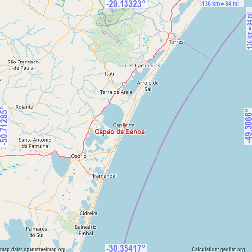
Capão da Canoa GPS coordinates[2]
29° 44' 44.016" South, 50° 0' 34.992" West
| Map corner | latitude | longitude |
|---|---|---|
| Upper-left | -29.13323°, | -50.71285° |
| Center: | -29.74556°, | -50.00972° |
| Lower-right: | -30.35417°, | -49.3066° |
| Map W x H: | 135.8×135.8 km | = 84.4×84.4mi |
| max Lat: | 2.81972° ⇑97.7% North |
| Capão da Canoa: | -29.74556° |
| min Lat: | ⇓2.3% South -33.69111° |
| min Long | Capão da Canoa | max Long |
| -72.89583° | -50.00972° | -32.41083° |
| W 21.7%⇐ | ⇒78.3% E |
Elevation
Elevation of Capão da Canoa is 6 m = 20 ft, and this is 374.9 m = 1230 ft below average elevation for this country.
| Max E: |
1603 m = 5259 ft | 98.3% |
| Avg. | 380.9 m = 1250 ft | |
| Capão da Canoa | 6 m = 20 ft | |
Min E: |
0 m = 0 ft | 1.7% |
See also: Brazil elevation on elevation.city.
Geographical zone
Capão da Canoa is located in South temperate zone (between Tropic of Capricorn and the Antarctic Circle). Distance of this Southern Tropic circle is 701.5 km =435.9 mi to North.| Distance of | km | miles | from Capão da Canoa |
|---|---|---|---|
| Equator | 3307.4 | 2055.1 | to North |
| Tropic Capricorn | 701.5 | 435.9 | to North |
| Antarctic Circle | 4093.8 | 2543.8 | to South |
| South Pole | 6699.7 | 4163 | to South |


Nearby cities:
15 places around Capão da Canoa: (largest is in red/bold)
• Canela
89 km =55.3 mi,  299°
299°
• Cidreira
52 km =32.3 mi,  201°
201°
• Gravataí
97.3 km =60.5 mi,  257°
257°
• Igrejinha
77.8 km =48.3 mi,  284°
284°
• Osório
29.6 km =18.4 mi,  237°
237°
• Palmares do Sul
74.6 km =46.4 mi,  220°
220°
• Parobé
80.7 km =50.1 mi, 279°
• Rolante
55.7 km =34.6 mi, 280°
• Sapiranga
97.1 km =60.3 mi, 277°
• Sombrio
79.9 km =49.6 mi,  28°
28°
• São Francisco de Paula
64.6 km =40.1 mi, 300°
• Taquara
75.2 km =46.7 mi, 278°
• Torres
53.2 km =33.1 mi, 30°
• Tramandaí
29.2 km =18.1 mi, 204°
• Três Coroas
78.5 km =48.8 mi,  288°
288°
Sources, notices
• [Note1] Compared only with cities in Brazil existing in our database
• [Src1] Map data: © OpenStreetMap contributors (CC-BY-SA)
• [Src2] Other city data from geonames.org with taken over terms of usage.
• [Src3] Geographical zone / Annual Mean Temperature by Robert A. Rohde @ Wikipedia
