Tramandaí geodata
Tramandaí (Rio Grande do Sul) is a populated place; located in Brazil in America/Sao_Paulo (GMT-3) time zone. With population of 34,734 people, there are 588 cities with bigger population in this country. Compared to other cities in Brazil, 98.5% of cities are located further ↑North; 78.9% of cities are located further →East and 95.4% of cities have higher elevation than Tramandaí. Note1


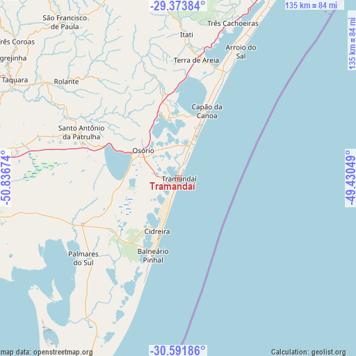
Tramandaí GPS coordinates[2]
29° 59' 4.992" South, 50° 8' 0.996" West
| Map corner | latitude | longitude |
|---|---|---|
| Upper-left | -29.37384°, | -50.83674° |
| Center: | -29.98472°, | -50.13361° |
| Lower-right: | -30.59186°, | -49.43049° |
| Map W x H: | 135.4×135.4 km | = 84.1×84.1mi |
| max Lat: | 2.81972° ⇑98.5% North |
| Tramandaí: | -29.98472° |
| min Lat: | ⇓1.5% South -33.69111° |
| min Long | Tramandaí | max Long |
| -72.89583° | -50.13361° | -32.41083° |
| W 21.1%⇐ | ⇒78.9% E |
Elevation
Elevation of Tramandaí is 9 m = 30 ft, and this is 371.9 m = 1220 ft below average elevation for this country.
| Max E: |
1603 m = 5259 ft | 95.4% |
| Avg. | 380.9 m = 1250 ft | |
| Tramandaí | 9 m = 30 ft | |
Min E: |
0 m = 0 ft | 4.6% |
See also: Brazil elevation on elevation.city.
Geographical zone
Tramandaí is located in South temperate zone (between Tropic of Capricorn and the Antarctic Circle). Distance of this Southern Tropic circle is 728.1 km =452.4 mi to North.| Distance of | km | miles | from Tramandaí |
|---|---|---|---|
| Equator | 3334 | 2071.7 | to North |
| Tropic Capricorn | 728.1 | 452.4 | to North |
| Antarctic Circle | 4067.2 | 2527.2 | to South |
| South Pole | 6673.1 | 4146.5 | to South |


Nearby cities:
15 places around Tramandaí: (largest is in red/bold)
• Cachoeirinha
92.6 km =57.5 mi,  272°
272°
• Capão da Canoa
29.2 km =18.1 mi,  24°
24°
• Cidreira
22.9 km =14.2 mi,  197°
197°
• Gravataí
82.9 km =51.5 mi, 273°
• Igrejinha
78.1 km =48.5 mi,  305°
305°
• Osório
17.1 km =10.6 mi, 309°
• Palmares do Sul
47.2 km =29.3 mi,  229°
229°
• Parobé
78.4 km =48.7 mi,  300°
300°
• Rolante
56.6 km =35.2 mi, 311°
• Sapiranga
92.7 km =57.6 mi,  294°
294°
• São Francisco de Paula
73.8 km =45.9 mi,  323°
323°
• Taquara
72.6 km =45.1 mi, 300°
• Torres
82.2 km =51.1 mi,  28°
28°
• Três Coroas
81.1 km =50.4 mi, 309°
• Viamão
86.3 km =53.6 mi,  262°
262°
Sources, notices
• [Note1] Compared only with cities in Brazil existing in our database
• [Src1] Map data: © OpenStreetMap contributors (CC-BY-SA)
• [Src2] Other city data from geonames.org with taken over terms of usage.
• [Src3] Geographical zone / Annual Mean Temperature by Robert A. Rohde @ Wikipedia
