Tijucas geodata
Tijucas (Santa Catarina) is a populated place; located in Brazil in America/Sao_Paulo (GMT-3) time zone. With population of 22,481 people, there are 855 cities with bigger population in this country. Compared to other cities in Brazil, 91.7% of cities are located further ↑North; 68.9% of cities are located further →East and 99% of cities have higher elevation than Tijucas. Note1


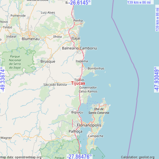
Tijucas GPS coordinates[2]
27° 14' 29.004" South, 48° 38' 0.996" West
| Map corner | latitude | longitude |
|---|---|---|
| Upper-left | -26.6145°, | -49.33674° |
| Center: | -27.24139°, | -48.63361° |
| Lower-right: | -27.86476°, | -47.93049° |
| Map W x H: | 139×139 km | = 86.4×86.4mi |
| max Lat: | 2.81972° ⇑91.7% North |
| Tijucas: | -27.24139° |
| min Lat: | ⇓8.3% South -33.69111° |
| min Long | Tijucas | max Long |
| -72.89583° | -48.63361° | -32.41083° |
| W 31.1%⇐ | ⇒68.9% E |
Elevation
Elevation of Tijucas is 5 m = 16 ft, and this is 375.9 m = 1233 ft below average elevation for this country.
| Max E: |
1603 m = 5259 ft | 99% |
| Avg. | 380.9 m = 1250 ft | |
| Tijucas | 5 m = 16 ft | |
Min E: |
0 m = 0 ft | 1% |
See also: Brazil elevation on elevation.city.
Geographical zone
Tijucas is located in South temperate zone (between Tropic of Capricorn and the Antarctic Circle). Distance of this Southern Tropic circle is 423 km =262.8 mi to North.| Distance of | km | miles | from Tijucas |
|---|---|---|---|
| Equator | 3029 | 1882.1 | to North |
| Tropic Capricorn | 423 | 262.8 | to North |
| Antarctic Circle | 4372.2 | 2716.8 | to South |
| South Pole | 6978.1 | 4336 | to South |


Nearby cities:
15 places around Tijucas: (largest is in red/bold)
• Balneário Camboriú
27.9 km =17.3 mi,  359°
359°
• Biguaçu
28.2 km =17.5 mi,  184°
184°
• Brusque
31.9 km =19.8 mi,  300°
300°
• Campinas
39.3 km =24.4 mi, 176°
• Carvoeira
41.1 km =25.5 mi,  165°
165°
• Florianópolis
40.4 km =25.1 mi, 168°
• Itacorubi
40.4 km =25.1 mi,  160°
160°
• Itajaí
37.2 km =23.1 mi, 355°
• Itapema
16.9 km =10.5 mi,  7°
7°
• Morro da Cruz
39.4 km =24.5 mi, 165°
• Navegantes
38.1 km =23.7 mi, 356°
• Porto Belo
12.2 km =7.6 mi,  40°
40°
• Santa Monica
40.9 km =25.4 mi, 162°
• São João Batista
21.7 km =13.5 mi,  259°
259°
• Trindade
39.8 km =24.7 mi, 164°
Sources, notices
• [Note1] Compared only with cities in Brazil existing in our database
• [Src1] Map data: © OpenStreetMap contributors (CC-BY-SA)
• [Src2] Other city data from geonames.org with taken over terms of usage.
• [Src3] Geographical zone / Annual Mean Temperature by Robert A. Rohde @ Wikipedia
