Navegantes geodata
Navegantes (Santa Catarina) is a populated place; located in Brazil in America/Sao_Paulo (GMT-3) time zone. With population of 47,781 people, there are 451 cities with bigger population in this country. Compared to other cities in Brazil, 90.9% of cities are located further ↑North; 69.1% of cities are located further →East and 97.2% of cities have higher elevation than Navegantes. Note1


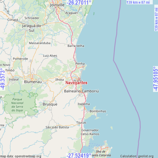
Navegantes GPS coordinates[2]
26° 53' 56.004" South, 48° 39' 15.012" West
| Map corner | latitude | longitude |
|---|---|---|
| Upper-left | -26.27011°, | -49.3573° |
| Center: | -26.89889°, | -48.65417° |
| Lower-right: | -27.52419°, | -47.95105° |
| Map W x H: | 139.4×139.4 km | = 86.6×86.6mi |
| max Lat: | 2.81972° ⇑90.9% North |
| Navegantes: | -26.89889° |
| min Lat: | ⇓9.1% South -33.69111° |
| min Long | Navegantes | max Long |
| -72.89583° | -48.65417° | -32.41083° |
| W 30.9%⇐ | ⇒69.1% E |
Elevation
Elevation of Navegantes is 7 m = 23 ft, and this is 373.9 m = 1227 ft below average elevation for this country.
| Max E: |
1603 m = 5259 ft | 97.2% |
| Avg. | 380.9 m = 1250 ft | |
| Navegantes | 7 m = 23 ft | |
Min E: |
0 m = 0 ft | 2.8% |
See also: Navegantes elevation on elevation.city.
Geographical zone
Navegantes is located in South temperate zone (between Tropic of Capricorn and the Antarctic Circle). Distance of this Southern Tropic circle is 385 km =239.2 mi to North.| Distance of | km | miles | from Navegantes |
|---|---|---|---|
| Equator | 2990.9 | 1858.5 | to North |
| Tropic Capricorn | 385 | 239.2 | to North |
| Antarctic Circle | 4410.3 | 2740.4 | to South |
| South Pole | 7016.2 | 4359.7 | to South |


Nearby cities:
15 places around Navegantes: (largest is in red/bold)
• Balneário Camboriú
10.4 km =6.5 mi,  169°
169°
• Barra Velha
29.8 km =18.5 mi,  354°
354°
• Blumenau
40.9 km =25.4 mi,  266°
266°
• Brusque
33.9 km =21.1 mi,  229°
229°
• Gaspar
30.4 km =18.9 mi,  263°
263°
• Guaramirim
58.7 km =36.5 mi,  323°
323°
• Indaial
57.3 km =35.6 mi, 270°
• Itajaí
1.3 km =0.8 mi,  217°
217°
• Itapema
21.7 km =13.5 mi, 168°
• Jaraguá do Sul
61.5 km =38.2 mi, 318°
• Penha
14.4 km =8.9 mi,  3°
3°
• Pomerode
54.8 km =34.1 mi,  288°
288°
• Porto Belo
30.5 km =19 mi,  160°
160°
• São João Batista
46.2 km =28.7 mi,  204°
204°
• Tijucas
38.1 km =23.7 mi,  176°
176°
Sources, notices
• [Note1] Compared only with cities in Brazil existing in our database
• [Src1] Map data: © OpenStreetMap contributors (CC-BY-SA)
• [Src2] Other city data from geonames.org with taken over terms of usage.
• [Src3] Geographical zone / Annual Mean Temperature by Robert A. Rohde @ Wikipedia
