Porto Belo geodata
Porto Belo (Santa Catarina) is a populated place; located in Brazil in America/Sao_Paulo (GMT-3) time zone. With population of 14,720 people, there are 1232 cities with bigger population in this country. Compared to other cities in Brazil, 91.5% of cities are located further ↑North; 68.1% of cities are located further →East and 99.5% of cities have higher elevation than Porto Belo. Note1


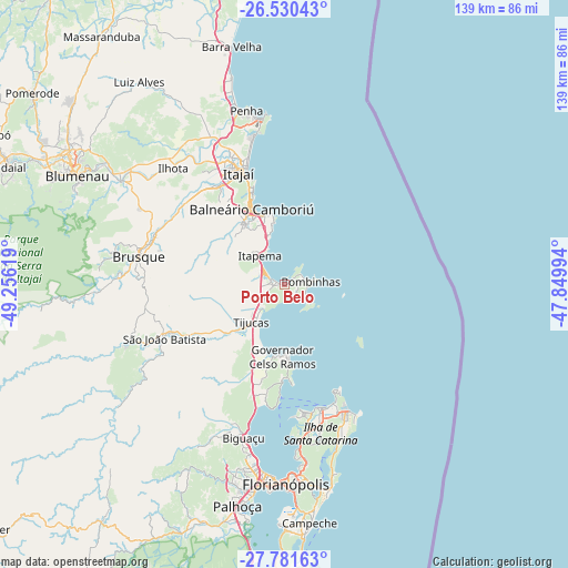
Porto Belo GPS coordinates[2]
27° 9' 28.008" South, 48° 33' 11.016" West
| Map corner | latitude | longitude |
|---|---|---|
| Upper-left | -26.53043°, | -49.25619° |
| Center: | -27.15778°, | -48.55306° |
| Lower-right: | -27.78163°, | -47.84994° |
| Map W x H: | 139.1×139.1 km | = 86.4×86.4mi |
| max Lat: | 2.81972° ⇑91.5% North |
| Porto Belo: | -27.15778° |
| min Lat: | ⇓8.5% South -33.69111° |
| min Long | Porto Belo | max Long |
| -72.89583° | -48.55306° | -32.41083° |
| W 31.9%⇐ | ⇒68.1% E |
Elevation
Elevation of Porto Belo is 3 m = 10 ft, and this is 377.9 m = 1240 ft below average elevation for this country.
| Max E: |
1603 m = 5259 ft | 99.5% |
| Avg. | 380.9 m = 1250 ft | |
| Porto Belo | 3 m = 10 ft | |
Min E: |
0 m = 0 ft | 0.5% |
See also: Brazil elevation on elevation.city.
Geographical zone
Porto Belo is located in South temperate zone (between Tropic of Capricorn and the Antarctic Circle). Distance of this Southern Tropic circle is 413.7 km =257.1 mi to North.| Distance of | km | miles | from Porto Belo |
|---|---|---|---|
| Equator | 3019.7 | 1876.4 | to North |
| Tropic Capricorn | 413.7 | 257.1 | to North |
| Antarctic Circle | 4381.5 | 2722.5 | to South |
| South Pole | 6987.4 | 4341.8 | to South |


Nearby cities:
15 places around Porto Belo: (largest is in red/bold)
• Balneário Camboriú
20.3 km =12.6 mi,  336°
336°
• Biguaçu
38.7 km =24 mi,  195°
195°
• Brusque
36.2 km =22.5 mi,  280°
280°
• Florianópolis
48.8 km =30.3 mi,  179°
179°
• Gaspar
47.4 km =29.5 mi,  302°
302°
• Itacorubi
47.6 km =29.6 mi,  173°
173°
• Itajaí
29.8 km =18.5 mi, 338°
• Itapema
9.5 km =5.9 mi,  322°
322°
• Morro da Cruz
47.5 km =29.5 mi, 177°
• Navegantes
30.5 km =19 mi, 340°
• Penha
44.1 km =27.4 mi,  347°
347°
• Santa Monica
48.4 km =30.1 mi, 174°
• São João Batista
32.1 km =19.9 mi,  245°
245°
• Tijucas
12.2 km =7.6 mi,  220°
220°
• Trindade
47.7 km =29.6 mi, 176°
Sources, notices
• [Note1] Compared only with cities in Brazil existing in our database
• [Src1] Map data: © OpenStreetMap contributors (CC-BY-SA)
• [Src2] Other city data from geonames.org with taken over terms of usage.
• [Src3] Geographical zone / Annual Mean Temperature by Robert A. Rohde @ Wikipedia
