Taquara geodata
Taquara (Rio Grande do Sul) is a populated place; located in Brazil in America/Sao_Paulo (GMT-3) time zone. With population of 48,051 people, there are 446 cities with bigger population in this country. Compared to other cities in Brazil, 97.4% of cities are located further ↑North; 81.5% of cities are located further →East and 84.1% of cities have higher elevation than Taquara. Note1


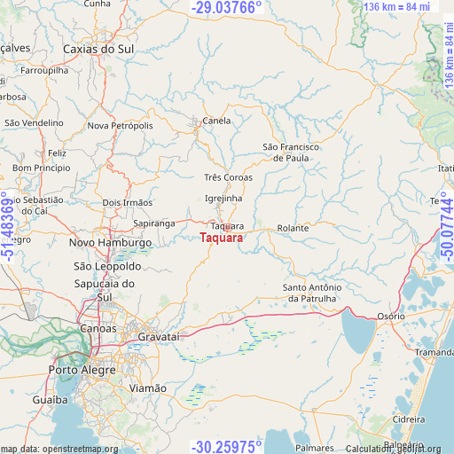
Taquara GPS coordinates[2]
29° 39' 2.016" South, 50° 46' 50.016" West
| Map corner | latitude | longitude |
|---|---|---|
| Upper-left | -29.03766°, | -51.48369° |
| Center: | -29.65056°, | -50.78056° |
| Lower-right: | -30.25975°, | -50.07744° |
| Map W x H: | 135.9×135.9 km | = 84.4×84.4mi |
| max Lat: | 2.81972° ⇑97.4% North |
| Taquara: | -29.65056° |
| min Lat: | ⇓2.6% South -33.69111° |
| min Long | Taquara | max Long |
| -72.89583° | -50.78056° | -32.41083° |
| W 18.5%⇐ | ⇒81.5% E |
Elevation
Elevation of Taquara is 33 m = 108 ft, and this is 347.9 m = 1141 ft below average elevation for this country.
| Max E: |
1603 m = 5259 ft | 84.1% |
| Avg. | 380.9 m = 1250 ft | |
| Taquara | 33 m = 108 ft | |
Min E: |
0 m = 0 ft | 15.9% |
See also: Taquara elevation on elevation.city.
Geographical zone
Taquara is located in South temperate zone (between Tropic of Capricorn and the Antarctic Circle). Distance of this Southern Tropic circle is 690.9 km =429.3 mi to North.| Distance of | km | miles | from Taquara |
|---|---|---|---|
| Equator | 3296.8 | 2048.5 | to North |
| Tropic Capricorn | 690.9 | 429.3 | to North |
| Antarctic Circle | 4104.3 | 2550.3 | to South |
| South Pole | 6710.2 | 4169.5 | to South |


Nearby cities:
15 places around Taquara: (largest is in red/bold)
• Canela
32.9 km =20.4 mi,  354°
354°
• Estância Velha
38 km =23.6 mi,  270°
270°
• Gravataí
38.3 km =23.8 mi,  212°
212°
• Igrejinha
8.5 km =5.3 mi, 353°
• Ivoti
37.3 km =23.2 mi,  280°
280°
• Nova Petrópolis
44.4 km =27.6 mi,  313°
313°
• Novo Hamburgo
34 km =21.1 mi,  264°
264°
• Parobé
5.8 km =3.6 mi,  294°
294°
• Portão
44.9 km =27.9 mi, 262°
• Rolante
19.8 km =12.3 mi,  90°
90°
• Sapiranga
21.9 km =13.6 mi, 273°
• Sapucaia
41 km =25.5 mi,  240°
240°
• São Francisco de Paula
29.5 km =18.3 mi,  40°
40°
• São Leopoldo
37.5 km =23.3 mi,  250°
250°
• Três Coroas
14.9 km =9.3 mi,  1°
1°
Sources, notices
• [Note1] Compared only with cities in Brazil existing in our database
• [Src1] Map data: © OpenStreetMap contributors (CC-BY-SA)
• [Src2] Other city data from geonames.org with taken over terms of usage.
• [Src3] Geographical zone / Annual Mean Temperature by Robert A. Rohde @ Wikipedia
