São Leopoldo geodata
São Leopoldo (Rio Grande do Sul) is a populated place; located in Brazil in America/Sao_Paulo (GMT-3) time zone. With population of 209,229 people, there are 109 cities with bigger population in this country. Compared to other cities in Brazil, 97.8% of cities are located further ↑North; 83.3% of cities are located further →East and 94.3% of cities have higher elevation than São Leopoldo. Note1


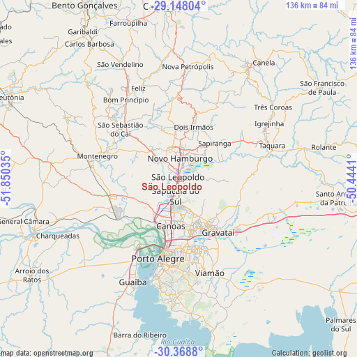
São Leopoldo GPS coordinates[2]
29° 45' 37.008" South, 51° 8' 49.992" West
| Map corner | latitude | longitude |
|---|---|---|
| Upper-left | -29.14804°, | -51.85035° |
| Center: | -29.76028°, | -51.14722° |
| Lower-right: | -30.3688°, | -50.4441° |
| Map W x H: | 135.7×135.7 km | = 84.3×84.3mi |
| max Lat: | 2.81972° ⇑97.8% North |
| São Leopoldo: | -29.76028° |
| min Lat: | ⇓2.2% South -33.69111° |
| min Long | São Leopoldo | max Long |
| -72.89583° | -51.14722° | -32.41083° |
| W 16.7%⇐ | ⇒83.3% E |
Elevation
Elevation of São Leopoldo is 10 m = 33 ft, and this is 370.9 m = 1217 ft below average elevation for this country.
| Max E: |
1603 m = 5259 ft | 94.3% |
| Avg. | 380.9 m = 1250 ft | |
| São Leopoldo | 10 m = 33 ft | |
Min E: |
0 m = 0 ft | 5.7% |
See also: São Leopoldo elevation on elevation.city.
Geographical zone
São Leopoldo is located in South temperate zone (between Tropic of Capricorn and the Antarctic Circle). Distance of this Southern Tropic circle is 703.1 km =436.9 mi to North.| Distance of | km | miles | from São Leopoldo |
|---|---|---|---|
| Equator | 3309 | 2056.1 | to North |
| Tropic Capricorn | 703.1 | 436.9 | to North |
| Antarctic Circle | 4092.1 | 2542.7 | to South |
| South Pole | 6698 | 4161.9 | to South |


Nearby cities:
15 places around São Leopoldo: (largest is in red/bold)
• Cachoeirinha
21.8 km =13.5 mi,  166°
166°
• Canoas
17.9 km =11.1 mi,  191°
191°
• Esteio
11.7 km =7.3 mi,  195°
195°
• Estância Velha
12.7 km =7.9 mi,  348°
348°
• Gravataí
25.1 km =15.6 mi,  143°
143°
• Ivoti
18.9 km =11.7 mi,  356°
356°
• Montenegro
31.3 km =19.4 mi,  284°
284°
• Novo Hamburgo
9.3 km =5.8 mi,  10°
10°
• Parobé
33.5 km =20.8 mi,  64°
64°
• Porto Alegre
31.3 km =19.4 mi, 194°
• Portão
11.2 km =7 mi,  305°
305°
• Sapiranga
19.2 km =11.9 mi,  44°
44°
• Sapucaia
8.1 km =5 mi,  181°
181°
• São Sebastião do Caí
29.3 km =18.2 mi, 311°
• Taquara
37.5 km =23.3 mi,  70°
70°
Sources, notices
• [Note1] Compared only with cities in Brazil existing in our database
• [Src1] Map data: © OpenStreetMap contributors (CC-BY-SA)
• [Src2] Other city data from geonames.org with taken over terms of usage.
• [Src3] Geographical zone / Annual Mean Temperature by Robert A. Rohde @ Wikipedia
