Ribeirão Pires geodata
Ribeirão Pires (São Paulo) is a populated place; located in Brazil in America/Sao_Paulo (GMT-3) time zone. With population of 111,888 people, there are 199 cities with bigger population in this country. Compared to other cities in Brazil, 84.5% of cities are located further ↑North; 54.5% of cities are located further →East and 85.2% of cities have lower elevation than Ribeirão Pires. Note1


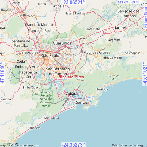
Ribeirão Pires GPS coordinates[2]
23° 42' 38.016" South, 46° 24' 47.988" West
| Map corner | latitude | longitude |
|---|---|---|
| Upper-left | -23.06521°, | -47.11646° |
| Center: | -23.71056°, | -46.41333° |
| Lower-right: | -24.35273°, | -45.71021° |
| Map W x H: | 143.2×143.2 km | = 89×89mi |
| max Lat: | 2.81972° ⇑84.5% North |
| Ribeirão Pires: | -23.71056° |
| min Lat: | ⇓15.5% South -33.69111° |
| min Long | Ribeirão Pires | max Long |
| -72.89583° | -46.41333° | -32.41083° |
| W 45.5%⇐ | ⇒54.5% E |
Elevation
Elevation of Ribeirão Pires is 760 m = 2493 ft, and this is 379.1 m = 1244 ft above average elevation for this country.
| Max E: |
1603 m = 5259 ft | 14.8% |
| Ribeirão Pires | 760 m 2493 ft | |
| Avg. | 380.9 m = 1250 ft | |
Min E: |
0 m = 0 ft | 85.2% |
See also: Ribeirão Pires elevation on elevation.city.
Geographical zone
Ribeirão Pires is located in South temperate zone (between Tropic of Capricorn and the Antarctic Circle). Distance of this Southern Tropic circle is 30.4 km =18.9 mi to North.| Distance of | km | miles | from Ribeirão Pires |
|---|---|---|---|
| Equator | 2636.4 | 1638.2 | to North |
| Tropic Capricorn | 30.4 | 18.9 | to North |
| Antarctic Circle | 4764.8 | 2960.7 | to South |
| South Pole | 7370.7 | 4579.9 | to South |


Nearby cities:
15 places around Ribeirão Pires: (largest is in red/bold)
• Cubatão
20.5 km =12.7 mi,  183°
183°
• Diadema
21.5 km =13.4 mi,  277°
277°
• Ferraz de Vasconcelos
19.4 km =12.1 mi,  13°
13°
• Itaquaquecetuba
25.8 km =16 mi, 14°
• Mauá
6.8 km =4.2 mi,  314°
314°
• Paraíso
28.5 km =17.7 mi,  301°
301°
• Poá
21.5 km =13.4 mi,  19°
19°
• Rio Grande da Serra
4 km =2.5 mi,  157°
157°
• Santo André
13.7 km =8.5 mi,  292°
292°
• Santos
29 km =18 mi, 163°
• Suzano
21.4 km =13.3 mi,  29°
29°
• São Bernardo do Campo
15.6 km =9.7 mi, 276°
• São Caetano do Sul
17.1 km =10.6 mi, 304°
• São Paulo
29 km =18 mi, 308°
• São Vicente
28.2 km =17.5 mi, 175°
Sources, notices
• [Note1] Compared only with cities in Brazil existing in our database
• [Src1] Map data: © OpenStreetMap contributors (CC-BY-SA)
• [Src2] Other city data from geonames.org with taken over terms of usage.
• [Src3] Geographical zone / Annual Mean Temperature by Robert A. Rohde @ Wikipedia
