Santo André geodata
Santo André (São Paulo) is a populated place; located in Brazil in America/Sao_Paulo (GMT-3) time zone. With population of 662,373 people, there are 24 cities with bigger population in this country. Compared to other cities in Brazil, 84.2% of cities are located further ↑North; 55.1% of cities are located further →East and 89.2% of cities have lower elevation than Santo André. Note1


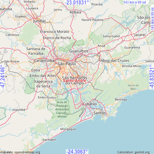
Santo André GPS coordinates[2]
23° 39' 50.004" South, 46° 32' 17.988" West
| Map corner | latitude | longitude |
|---|---|---|
| Upper-left | -23.01831°, | -47.24146° |
| Center: | -23.66389°, | -46.53833° |
| Lower-right: | -24.3063°, | -45.83521° |
| Map W x H: | 143.2×143.2 km | = 89×89mi |
| max Lat: | 2.81972° ⇑84.2% North |
| Santo André: | -23.66389° |
| min Lat: | ⇓15.8% South -33.69111° |
| min Long | Santo André | max Long |
| -72.89583° | -46.53833° | -32.41083° |
| W 44.9%⇐ | ⇒55.1% E |
Elevation
Elevation of Santo André is 801 m = 2628 ft, and this is 420.1 m = 1378 ft above average elevation for this country.
| Max E: |
1603 m = 5259 ft | 10.8% |
| Santo André | 801 m 2628 ft | |
| Avg. | 380.9 m = 1250 ft | |
Min E: |
0 m = 0 ft | 89.2% |
See also: Santo André elevation on elevation.city.
Geographical zone
Santo André is located in South temperate zone (between Tropic of Capricorn and the Antarctic Circle). Distance of this Southern Tropic circle is 25.3 km =15.7 mi to North.| Distance of | km | miles | from Santo André |
|---|---|---|---|
| Equator | 2631.2 | 1635 | to North |
| Tropic Capricorn | 25.3 | 15.7 | to North |
| Antarctic Circle | 4770 | 2963.9 | to South |
| South Pole | 7375.9 | 4583.2 | to South |


Nearby cities:
15 places around Santo André: (largest is in red/bold)
• Diadema
8.9 km =5.5 mi,  253°
253°
• Ferraz de Vasconcelos
22.1 km =13.7 mi,  51°
51°
• Guarulhos
22.4 km =13.9 mi,  1°
1°
• Itaquaquecetuba
27.7 km =17.2 mi,  44°
44°
• Jardim Paulista
16.8 km =10.4 mi,  310°
310°
• Mauá
7.8 km =4.8 mi,  93°
93°
• Paraíso
15.1 km =9.4 mi, 310°
• Poá
24.8 km =15.4 mi, 52°
• Ribeirão Pires
13.7 km =8.5 mi,  112°
112°
• Rio Grande da Serra
16.8 km =10.4 mi,  122°
122°
• Suzano
26.8 km =16.7 mi,  59°
59°
• São Bernardo do Campo
4.3 km =2.7 mi,  219°
219°
• São Caetano do Sul
4.7 km =2.9 mi,  344°
344°
• São Paulo
16.3 km =10.1 mi,  322°
322°
• Taboão da Serra
26.1 km =16.2 mi,  279°
279°
Sources, notices
• [Note1] Compared only with cities in Brazil existing in our database
• [Src1] Map data: © OpenStreetMap contributors (CC-BY-SA)
• [Src2] Other city data from geonames.org with taken over terms of usage.
• [Src3] Geographical zone / Annual Mean Temperature by Robert A. Rohde @ Wikipedia
