Santo Amaro geodata
Santo Amaro (Bahia) is a populated place; located in Brazil in America/Bahia (GMT-3) time zone. With population of 46,748 people, there are 459 cities with bigger population in this country. Compared to other cities in Brazil, 61% of cities are located further ↓South; 81.6% of cities are located further ←West and 93.7% of cities have higher elevation than Santo Amaro. Note1


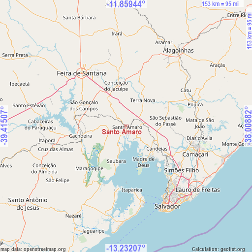
Santo Amaro GPS coordinates[2]
12° 32' 48.012" South, 38° 42' 42.984" West
| Map corner | latitude | longitude |
|---|---|---|
| Upper-left | -11.85944°, | -39.41507° |
| Center: | -12.54667°, | -38.71194° |
| Lower-right: | -13.23207°, | -38.00882° |
| Map W x H: | 152.6×152.6 km | = 94.8×94.8mi |
| max Lat: | 2.81972° ⇑39% North |
| Santo Amaro: | -12.54667° |
| min Lat: | ⇓61% South -33.69111° |
| min Long | Santo Amaro | max Long |
| -72.89583° | -38.71194° | -32.41083° |
| W 81.6%⇐ | ⇒18.4% E |
Elevation
Elevation of Santo Amaro is 11 m = 36 ft, and this is 369.9 m = 1214 ft below average elevation for this country.
| Max E: |
1603 m = 5259 ft | 93.7% |
| Avg. | 380.9 m = 1250 ft | |
| Santo Amaro | 11 m = 36 ft | |
Min E: |
0 m = 0 ft | 6.3% |
See also: Santo Amaro elevation on elevation.city.
Geographical zone
Santo Amaro is located in South Torrid zone (between Equator and Tropic of Capricorn). Distance of this Southern Tropic circle is 1210.9 km =752.4 mi to South.| Distance of | km | miles | from Santo Amaro |
|---|---|---|---|
| Equator | 1395.1 | 866.9 | to North |
| Tropic Capricorn | 1210.9 | 752.4 | to South |
| Antarctic Circle | 6006.1 | 3732 | to South |
| South Pole | 8612 | 5351.2 | to South |


Nearby cities:
15 places around Santo Amaro: (largest is in red/bold)
• Cachoeira
28.2 km =17.5 mi,  257°
257°
• Catu
42.1 km =26.2 mi,  59°
59°
• Conceição da Feira
31.4 km =19.5 mi,  278°
278°
• Conceição do Jacuípe
26.3 km =16.3 mi,  346°
346°
• Coração de Maria
35.1 km =21.8 mi, 353°
• Cruz das Almas
44.5 km =27.7 mi,  252°
252°
• Feira de Santana
41.6 km =25.8 mi,  318°
318°
• Itaparica
38.2 km =23.7 mi,  174°
174°
• Madre de Deus
23.7 km =14.7 mi,  155°
155°
• Maragogipe
34.2 km =21.3 mi,  221°
221°
• Saubara
22.1 km =13.7 mi,  196°
196°
• Simões Filho
42.6 km =26.5 mi,  128°
128°
• São Francisco do Conde
9.6 km =6 mi, 158°
• São Gonçalo dos Campos
30.4 km =18.9 mi,  294°
294°
• São Sebastião do Passé
23.8 km =14.8 mi,  80°
80°
Sources, notices
• [Note1] Compared only with cities in Brazil existing in our database
• [Src1] Map data: © OpenStreetMap contributors (CC-BY-SA)
• [Src2] Other city data from geonames.org with taken over terms of usage.
• [Src3] Geographical zone / Annual Mean Temperature by Robert A. Rohde @ Wikipedia
