Maragogipe geodata
Maragogipe (Bahia) is a populated place; located in Brazil in America/Bahia (GMT-3) time zone. With population of 20,921 people, there are 909 cities with bigger population in this country. Compared to other cities in Brazil, 60.4% of cities are located further ↓South; 80.9% of cities are located further ←West and 92.4% of cities have higher elevation than Maragogipe. Note1


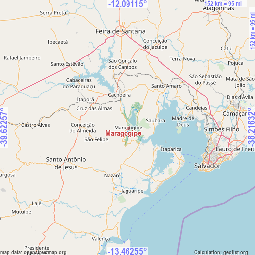
Maragogipe GPS coordinates[2]
12° 46' 40.008" South, 38° 55' 9.984" West
| Map corner | latitude | longitude |
|---|---|---|
| Upper-left | -12.09115°, | -39.62257° |
| Center: | -12.77778°, | -38.91944° |
| Lower-right: | -13.46255°, | -38.21632° |
| Map W x H: | 152.5×152.5 km | = 94.8×94.8mi |
| max Lat: | 2.81972° ⇑39.6% North |
| Maragogipe: | -12.77778° |
| min Lat: | ⇓60.4% South -33.69111° |
| min Long | Maragogipe | max Long |
| -72.89583° | -38.91944° | -32.41083° |
| W 80.9%⇐ | ⇒19.1% E |
Elevation
Elevation of Maragogipe is 13 m = 43 ft, and this is 367.9 m = 1207 ft below average elevation for this country.
| Max E: |
1603 m = 5259 ft | 92.4% |
| Avg. | 380.9 m = 1250 ft | |
| Maragogipe | 13 m = 43 ft | |
Min E: |
0 m = 0 ft | 7.6% |
See also: Brazil elevation on elevation.city.
Geographical zone
Maragogipe is located in South Torrid zone (between Equator and Tropic of Capricorn). Distance of this Southern Tropic circle is 1185.2 km =736.4 mi to South.| Distance of | km | miles | from Maragogipe |
|---|---|---|---|
| Equator | 1420.8 | 882.8 | to North |
| Tropic Capricorn | 1185.2 | 736.4 | to South |
| Antarctic Circle | 5980.4 | 3716 | to South |
| South Pole | 8586.3 | 5335.3 | to South |


Nearby cities:
15 places around Maragogipe: (largest is in red/bold)
• Cachoeira
20.2 km =12.6 mi,  345°
345°
• Conceição da Feira
31.4 km =19.5 mi,  344°
344°
• Conceição do Almeida
27.2 km =16.9 mi,  269°
269°
• Cruz das Almas
23.1 km =14.4 mi,  301°
301°
• Itaparica
28.9 km =18 mi,  115°
115°
• Madre de Deus
32.6 km =20.3 mi,  82°
82°
• Muritiba
39 km =24.2 mi,  246°
246°
• Nazaré
30.4 km =18.9 mi,  199°
199°
• Salvador
49.2 km =30.6 mi, 115°
• Santo Amaro
34.2 km =21.3 mi,  41°
41°
• Santo Antônio de Jesus
42.7 km =26.5 mi,  240°
240°
• Saubara
17 km =10.6 mi,  74°
74°
• Sobradinho
20.5 km =12.7 mi, 252°
• São Francisco do Conde
30.9 km =19.2 mi,  57°
57°
• São Gonçalo dos Campos
38.6 km =24 mi, 352°
Sources, notices
• [Note1] Compared only with cities in Brazil existing in our database
• [Src1] Map data: © OpenStreetMap contributors (CC-BY-SA)
• [Src2] Other city data from geonames.org with taken over terms of usage.
• [Src3] Geographical zone / Annual Mean Temperature by Robert A. Rohde @ Wikipedia
