Itaparica geodata
Itaparica (Bahia) is a populated place; located in Brazil in America/Bahia (GMT-3) time zone. With population of 20,100 people, there are 933 cities with bigger population in this country. Compared to other cities in Brazil, 60.2% of cities are located further ↓South; 81.7% of cities are located further ←West and 88.9% of cities have higher elevation than Itaparica. Note1


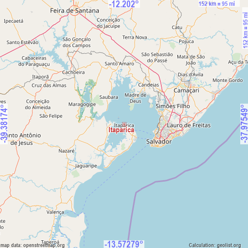
Itaparica GPS coordinates[2]
12° 53' 17.988" South, 38° 40' 42.996" West
| Map corner | latitude | longitude |
|---|---|---|
| Upper-left | -12.202°, | -39.38174° |
| Center: | -12.88833°, | -38.67861° |
| Lower-right: | -13.57279°, | -37.97549° |
| Map W x H: | 152.4×152.4 km | = 94.7×94.7mi |
| max Lat: | 2.81972° ⇑39.8% North |
| Itaparica: | -12.88833° |
| min Lat: | ⇓60.2% South -33.69111° |
| min Long | Itaparica | max Long |
| -72.89583° | -38.67861° | -32.41083° |
| W 81.7%⇐ | ⇒18.3% E |
Elevation
Elevation of Itaparica is 20 m = 66 ft, and this is 360.9 m = 1184 ft below average elevation for this country.
| Max E: |
1603 m = 5259 ft | 88.9% |
| Avg. | 380.9 m = 1250 ft | |
| Itaparica | 20 m = 66 ft | |
Min E: |
0 m = 0 ft | 11.1% |
See also: Brazil elevation on elevation.city.
Geographical zone
Itaparica is located in South Torrid zone (between Equator and Tropic of Capricorn). Distance of this Southern Tropic circle is 1172.9 km =728.8 mi to South.| Distance of | km | miles | from Itaparica |
|---|---|---|---|
| Equator | 1433 | 890.4 | to North |
| Tropic Capricorn | 1172.9 | 728.8 | to South |
| Antarctic Circle | 5968.1 | 3708.4 | to South |
| South Pole | 8574 | 5327.6 | to South |


Nearby cities:
15 places around Itaparica: (largest is in red/bold)
• Cachoeira
44.6 km =27.7 mi,  315°
315°
• Camaçari
43.9 km =27.3 mi,  61°
61°
• Conceição do Almeida
54.6 km =33.9 mi,  282°
282°
• Cruz das Almas
51.9 km =32.2 mi,  297°
297°
• Lauro de Freitas
38.1 km =23.7 mi,  91°
91°
• Madre de Deus
17.6 km =10.9 mi,  20°
20°
• Maragogipe
28.9 km =18 mi, 295°
• Nazaré
39.9 km =24.8 mi,  245°
245°
• Salvador
20.4 km =12.7 mi,  116°
116°
• Santo Amaro
38.2 km =23.7 mi,  354°
354°
• Saubara
19.4 km =12.1 mi,  329°
329°
• Simões Filho
31.9 km =19.8 mi,  68°
68°
• Sobradinho
46.1 km =28.6 mi, 277°
• São Francisco do Conde
29 km =18 mi,  359°
359°
• São Sebastião do Passé
46.3 km =28.8 mi,  25°
25°
Sources, notices
• [Note1] Compared only with cities in Brazil existing in our database
• [Src1] Map data: © OpenStreetMap contributors (CC-BY-SA)
• [Src2] Other city data from geonames.org with taken over terms of usage.
• [Src3] Geographical zone / Annual Mean Temperature by Robert A. Rohde @ Wikipedia
