Cruz das Almas geodata
Cruz das Almas (Bahia) is a populated place; located in Brazil in America/Bahia (GMT-3) time zone. With population of 47,844 people, there are 450 cities with bigger population in this country. Compared to other cities in Brazil, 60.8% of cities are located further ↓South; 79.5% of cities are located further ←West and 58.8% of cities have higher elevation than Cruz das Almas. Note1


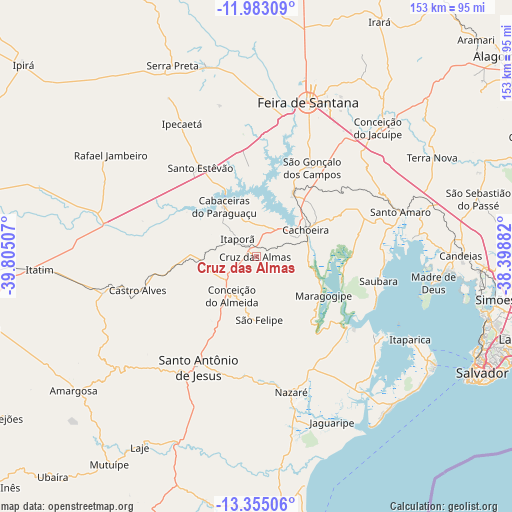
Cruz das Almas GPS coordinates[2]
12° 40' 12" South, 39° 6' 6.984" West
| Map corner | latitude | longitude |
|---|---|---|
| Upper-left | -11.98309°, | -39.80507° |
| Center: | -12.67°, | -39.10194° |
| Lower-right: | -13.35506°, | -38.39882° |
| Map W x H: | 152.5×152.6 km | = 94.8×94.8mi |
| max Lat: | 2.81972° ⇑39.2% North |
| Cruz das Almas: | -12.67° |
| min Lat: | ⇓60.8% South -33.69111° |
| min Long | Cruz das Almas | max Long |
| -72.89583° | -39.10194° | -32.41083° |
| W 79.5%⇐ | ⇒20.5% E |
Elevation
Elevation of Cruz das Almas is 224 m = 735 ft, and this is 156.9 m = 515 ft below average elevation for this country.
| Max E: |
1603 m = 5259 ft | 58.8% |
| Avg. | 380.9 m = 1250 ft | |
| Cruz das Almas | 224 m = 735 ft | |
Min E: |
0 m = 0 ft | 41.2% |
See also: Cruz das Almas elevation on elevation.city.
Geographical zone
Cruz das Almas is located in South Torrid zone (between Equator and Tropic of Capricorn). Distance of this Southern Tropic circle is 1197.1 km =743.8 mi to South.| Distance of | km | miles | from Cruz das Almas |
|---|---|---|---|
| Equator | 1408.8 | 875.4 | to North |
| Tropic Capricorn | 1197.1 | 743.8 | to South |
| Antarctic Circle | 5992.4 | 3723.5 | to South |
| South Pole | 8598.3 | 5342.7 | to South |


Nearby cities:
15 places around Cruz das Almas: (largest is in red/bold)
• Cachoeira
16.6 km =10.3 mi,  62°
62°
• Castro Alves
37 km =23 mi,  253°
253°
• Conceição da Feira
21.4 km =13.3 mi,  31°
31°
• Conceição do Almeida
14.2 km =8.8 mi,  211°
211°
• Feira de Santana
47.2 km =29.3 mi,  18°
18°
• Maragogipe
23.1 km =14.4 mi,  121°
121°
• Muritiba
31.8 km =19.8 mi, 210°
• Nazaré
41.7 km =25.9 mi,  166°
166°
• Santo Amaro
44.5 km =27.7 mi,  72°
72°
• Santo Antônio de Jesus
37.5 km =23.3 mi, 207°
• Santo Estêvão
31.2 km =19.4 mi,  328°
328°
• Saubara
36.9 km =22.9 mi,  101°
101°
• Sobradinho
18.2 km =11.3 mi,  179°
179°
• São Francisco do Conde
46 km =28.6 mi,  84°
84°
• São Gonçalo dos Campos
30.1 km =18.7 mi, 29°
Sources, notices
• [Note1] Compared only with cities in Brazil existing in our database
• [Src1] Map data: © OpenStreetMap contributors (CC-BY-SA)
• [Src2] Other city data from geonames.org with taken over terms of usage.
• [Src3] Geographical zone / Annual Mean Temperature by Robert A. Rohde @ Wikipedia
