Nova Odessa geodata
Nova Odessa (São Paulo) is a populated place; located in Brazil in America/Sao_Paulo (GMT-3) time zone. With population of 49,432 people, there are 430 cities with bigger population in this country. Compared to other cities in Brazil, 76.5% of cities are located further ↑North; 60.2% of cities are located further →East and 69.4% of cities have lower elevation than Nova Odessa. Note1


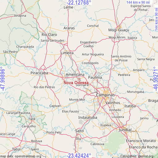
Nova Odessa GPS coordinates[2]
22° 46' 39" South, 47° 17' 44.988" West
| Map corner | latitude | longitude |
|---|---|---|
| Upper-left | -22.12768°, | -47.99896° |
| Center: | -22.7775°, | -47.29583° |
| Lower-right: | -23.42424°, | -46.59271° |
| Map W x H: | 144.2×144.2 km | = 89.6×89.6mi |
| max Lat: | 2.81972° ⇑76.5% North |
| Nova Odessa: | -22.7775° |
| min Lat: | ⇓23.5% South -33.69111° |
| min Long | Nova Odessa | max Long |
| -72.89583° | -47.29583° | -32.41083° |
| W 39.8%⇐ | ⇒60.2% E |
Elevation
Elevation of Nova Odessa is 569 m = 1867 ft, and this is 188.1 m = 617 ft above average elevation for this country.
| Max E: |
1603 m = 5259 ft | 30.6% |
| Nova Odessa | 569 m 1867 ft | |
| Avg. | 380.9 m = 1250 ft | |
Min E: |
0 m = 0 ft | 69.4% |
See also: Nova Odessa elevation on elevation.city.
Geographical zone
Nova Odessa is located in South Torrid zone (between Equator and Tropic of Capricorn). Distance of this Southern Tropic circle is 73.3 km =45.5 mi to South.| Distance of | km | miles | from Nova Odessa |
|---|---|---|---|
| Equator | 2532.6 | 1573.7 | to North |
| Tropic Capricorn | 73.3 | 45.5 | to South |
| Antarctic Circle | 4868.6 | 3025.2 | to South |
| South Pole | 7474.4 | 4644.4 | to South |


Nearby cities:
15 places around Nova Odessa: (largest is in red/bold)
• Americana
5.6 km =3.5 mi,  319°
319°
• Artur Nogueira
26 km =16.2 mi,  29°
29°
• Campinas
28 km =17.4 mi,  120°
120°
• Capivari
32.5 km =20.2 mi,  221°
221°
• Cosmópolis
17.9 km =11.1 mi, 34°
• Elias Fausto
30.6 km =19 mi,  195°
195°
• Hortolândia
11.9 km =7.4 mi,  139°
139°
• Iracemápolis
31.7 km =19.7 mi,  313°
313°
• Jaguariúna
32.8 km =20.4 mi,  75°
75°
• Limeira
26 km =16.2 mi,  335°
335°
• Monte Mor
18.9 km =11.7 mi,  186°
186°
• Paulínia
14.6 km =9.1 mi, 82°
• Rio das Pedras
32.6 km =20.3 mi,  257°
257°
• Santa Bárbara d'Oeste
12.4 km =7.7 mi,  282°
282°
• Sumaré
5.8 km =3.6 mi,  149°
149°
Sources, notices
• [Note1] Compared only with cities in Brazil existing in our database
• [Src1] Map data: © OpenStreetMap contributors (CC-BY-SA)
• [Src2] Other city data from geonames.org with taken over terms of usage.
• [Src3] Geographical zone / Annual Mean Temperature by Robert A. Rohde @ Wikipedia
