Campinas geodata
Campinas (São Paulo) is a populated place; located in Brazil in America/Sao_Paulo (GMT-3) time zone. With population of 1,031,554 people, there are 13 cities with bigger population in this country. Compared to other cities in Brazil, 77.7% of cities are located further ↑North; 59.1% of cities are located further →East and 79.8% of cities have lower elevation than Campinas. Note1


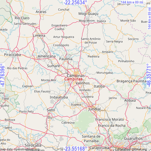
Campinas GPS coordinates[2]
22° 54' 20.016" South, 47° 3' 38.988" West
| Map corner | latitude | longitude |
|---|---|---|
| Upper-left | -22.25634°, | -47.76396° |
| Center: | -22.90556°, | -47.06083° |
| Lower-right: | -23.55168°, | -46.35771° |
| Map W x H: | 144×144 km | = 89.5×89.5mi |
| max Lat: | 2.81972° ⇑77.7% North |
| Campinas: | -22.90556° |
| min Lat: | ⇓22.3% South -33.69111° |
| min Long | Campinas | max Long |
| -72.89583° | -47.06083° | -32.41083° |
| W 40.9%⇐ | ⇒59.1% E |
Elevation
Elevation of Campinas is 686 m = 2251 ft, and this is 305.1 m = 1001 ft above average elevation for this country.
| Max E: |
1603 m = 5259 ft | 20.2% |
| Campinas | 686 m 2251 ft | |
| Avg. | 380.9 m = 1250 ft | |
Min E: |
0 m = 0 ft | 79.8% |
See also: Campinas elevation on elevation.city.
Geographical zone
Campinas is located in South Torrid zone (between Equator and Tropic of Capricorn). Distance of this Southern Tropic circle is 59.1 km =36.7 mi to South.| Distance of | km | miles | from Campinas |
|---|---|---|---|
| Equator | 2546.9 | 1582.6 | to North |
| Tropic Capricorn | 59.1 | 36.7 | to South |
| Antarctic Circle | 4854.3 | 3016.3 | to South |
| South Pole | 7460.2 | 4635.6 | to South |


Nearby cities:
15 places around Campinas: (largest is in red/bold)
• Americana
33.3 km =20.7 mi,  303°
303°
• Cosmópolis
32 km =19.9 mi,  334°
334°
• Hortolândia
17.1 km =10.6 mi,  287°
287°
• Indaiatuba
25.5 km =15.8 mi,  217°
217°
• Itatiba
25.3 km =15.7 mi,  116°
116°
• Itupeva
27.5 km =17.1 mi,  179°
179°
• Jaguariúna
23.5 km =14.6 mi,  19°
19°
• Louveira
23.1 km =14.4 mi,  150°
150°
• Monte Mor
26.5 km =16.5 mi,  260°
260°
• Nova Odessa
28 km =17.4 mi, 300°
• Paulínia
18.7 km =11.6 mi, 329°
• Pedreira
24.5 km =15.2 mi,  41°
41°
• Sumaré
23.1 km =14.4 mi, 293°
• Valinhos
9.8 km =6.1 mi,  137°
137°
• Vinhedo
16.3 km =10.1 mi, 147°
Sources, notices
• [Note1] Compared only with cities in Brazil existing in our database
• [Src1] Map data: © OpenStreetMap contributors (CC-BY-SA)
• [Src2] Other city data from geonames.org with taken over terms of usage.
• [Src3] Geographical zone / Annual Mean Temperature by Robert A. Rohde @ Wikipedia
