Paulínia geodata
Paulínia (São Paulo) is a seat of a second-order administrative division; located in Brazil in America/Sao_Paulo (GMT-3) time zone. With population of 65,595 people, there are 337 cities with bigger population in this country. Compared to other cities in Brazil, 76.4% of cities are located further ↑North; 59.4% of cities are located further →East and 71.6% of cities have lower elevation than Paulínia. Note1


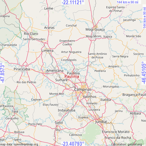
Paulínia GPS coordinates[2]
22° 45' 39.996" South, 47° 9' 15.012" West
| Map corner | latitude | longitude |
|---|---|---|
| Upper-left | -22.11121°, | -47.8573° |
| Center: | -22.76111°, | -47.15417° |
| Lower-right: | -23.40793°, | -46.45105° |
| Map W x H: | 144.2×144.2 km | = 89.6×89.6mi |
| max Lat: | 2.81972° ⇑76.4% North |
| Paulínia: | -22.76111° |
| min Lat: | ⇓23.6% South -33.69111° |
| min Long | Paulínia | max Long |
| -72.89583° | -47.15417° | -32.41083° |
| W 40.6%⇐ | ⇒59.4% E |
Elevation
Elevation of Paulínia is 588 m = 1929 ft, and this is 207.1 m = 679 ft above average elevation for this country.
| Max E: |
1603 m = 5259 ft | 28.4% |
| Paulínia | 588 m 1929 ft | |
| Avg. | 380.9 m = 1250 ft | |
Min E: |
0 m = 0 ft | 71.6% |
See also: Paulínia elevation on elevation.city.
Geographical zone
Paulínia is located in South Torrid zone (between Equator and Tropic of Capricorn). Distance of this Southern Tropic circle is 75.1 km =46.7 mi to South.| Distance of | km | miles | from Paulínia |
|---|---|---|---|
| Equator | 2530.8 | 1572.6 | to North |
| Tropic Capricorn | 75.1 | 46.7 | to South |
| Antarctic Circle | 4870.4 | 3026.3 | to South |
| South Pole | 7476.3 | 4645.6 | to South |


Nearby cities:
15 places around Paulínia: (largest is in red/bold)
• Americana
18.3 km =11.4 mi,  277°
277°
• Artur Nogueira
21 km =13 mi,  354°
354°
• Campinas
18.7 km =11.6 mi,  149°
149°
• Cosmópolis
13.5 km =8.4 mi,  341°
341°
• Hortolândia
12.7 km =7.9 mi,  211°
211°
• Jaguariúna
18.3 km =11.4 mi,  70°
70°
• Limeira
33.5 km =20.8 mi,  310°
310°
• Monte Mor
26.5 km =16.5 mi,  218°
218°
• Nova Odessa
14.6 km =9.1 mi,  262°
262°
• Pedreira
26 km =16.2 mi,  85°
85°
• Santa Bárbara d'Oeste
26.6 km =16.5 mi,  271°
271°
• Santo Antônio de Posse
29.6 km =18.4 mi,  54°
54°
• Sumaré
13.4 km =8.3 mi,  239°
239°
• Valinhos
28.4 km =17.6 mi, 145°
• Vinhedo
35 km =21.7 mi, 148°
Sources, notices
• [Note1] Compared only with cities in Brazil existing in our database
• [Src1] Map data: © OpenStreetMap contributors (CC-BY-SA)
• [Src2] Other city data from geonames.org with taken over terms of usage.
• [Src3] Geographical zone / Annual Mean Temperature by Robert A. Rohde @ Wikipedia
