Monte Mor geodata
Monte Mor (São Paulo) is a populated place; located in Brazil in America/Sao_Paulo (GMT-3) time zone. With population of 40,290 people, there are 526 cities with bigger population in this country. Compared to other cities in Brazil, 78.1% of cities are located further ↑North; 60.3% of cities are located further →East and 68.4% of cities have lower elevation than Monte Mor. Note1


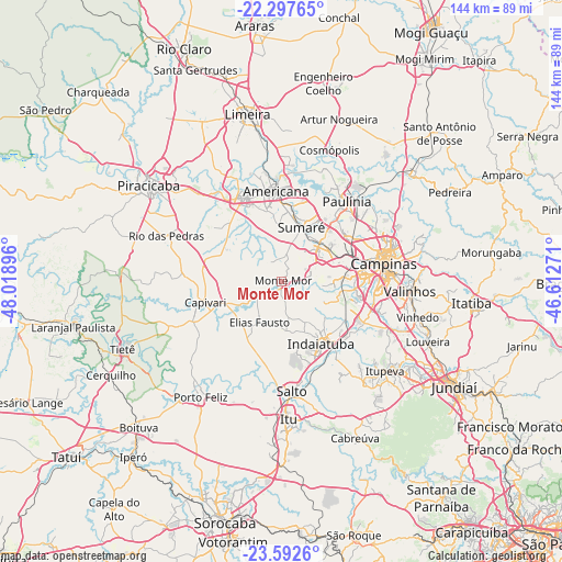
Monte Mor GPS coordinates[2]
22° 56' 48.012" South, 47° 18' 56.988" West
| Map corner | latitude | longitude |
|---|---|---|
| Upper-left | -22.29765°, | -48.01896° |
| Center: | -22.94667°, | -47.31583° |
| Lower-right: | -23.5926°, | -46.61271° |
| Map W x H: | 144×144 km | = 89.5×89.5mi |
| max Lat: | 2.81972° ⇑78.1% North |
| Monte Mor: | -22.94667° |
| min Lat: | ⇓21.9% South -33.69111° |
| min Long | Monte Mor | max Long |
| -72.89583° | -47.31583° | -32.41083° |
| W 39.7%⇐ | ⇒60.3% E |
Elevation
Elevation of Monte Mor is 561 m = 1841 ft, and this is 180.1 m = 591 ft above average elevation for this country.
| Max E: |
1603 m = 5259 ft | 31.6% |
| Monte Mor | 561 m 1841 ft | |
| Avg. | 380.9 m = 1250 ft | |
Min E: |
0 m = 0 ft | 68.4% |
See also: Monte Mor elevation on elevation.city.
Geographical zone
Monte Mor is located in South Torrid zone (between Equator and Tropic of Capricorn). Distance of this Southern Tropic circle is 54.5 km =33.9 mi to South.| Distance of | km | miles | from Monte Mor |
|---|---|---|---|
| Equator | 2551.4 | 1585.4 | to North |
| Tropic Capricorn | 54.5 | 33.9 | to South |
| Antarctic Circle | 4849.7 | 3013.5 | to South |
| South Pole | 7455.6 | 4632.7 | to South |


Nearby cities:
15 places around Monte Mor: (largest is in red/bold)
• Americana
23.1 km =14.4 mi,  356°
356°
• Campinas
26.5 km =16.5 mi,  80°
80°
• Capivari
20.4 km =12.7 mi,  254°
254°
• Elias Fausto
12.2 km =7.6 mi,  209°
209°
• Hortolândia
13.9 km =8.6 mi,  44°
44°
• Indaiatuba
19 km =11.8 mi,  145°
145°
• Itu
35.3 km =21.9 mi,  177°
177°
• Itupeva
35 km =21.7 mi,  130°
130°
• Nova Odessa
18.9 km =11.7 mi,  6°
6°
• Paulínia
26.5 km =16.5 mi, 38°
• Rio das Pedras
31.9 km =19.8 mi,  291°
291°
• Salto
28.4 km =17.6 mi,  174°
174°
• Santa Bárbara d'Oeste
23.7 km =14.7 mi,  334°
334°
• Sumaré
14.7 km =9.1 mi,  19°
19°
• Valinhos
32.9 km =20.4 mi,  94°
94°
Sources, notices
• [Note1] Compared only with cities in Brazil existing in our database
• [Src1] Map data: © OpenStreetMap contributors (CC-BY-SA)
• [Src2] Other city data from geonames.org with taken over terms of usage.
• [Src3] Geographical zone / Annual Mean Temperature by Robert A. Rohde @ Wikipedia
