Frei Paulo geodata
Frei Paulo (Sergipe) is a populated place; located in Brazil in America/Maceio (GMT-3) time zone. With population of 7,047 people, there are 1828 cities with bigger population in this country. Compared to other cities in Brazil, 66.3% of cities are located further ↓South; 86.6% of cities are located further ←West and 54.4% of cities have higher elevation than Frei Paulo. Note1


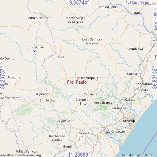
Frei Paulo GPS coordinates[2]
10° 32' 57.984" South, 37° 32' 3.984" West
| Map corner | latitude | longitude |
|---|---|---|
| Upper-left | -9.85744°, | -38.23757° |
| Center: | -10.54944°, | -37.53444° |
| Lower-right: | -11.23989°, | -36.83132° |
| Map W x H: | 153.7×153.7 km | = 95.5×95.5mi |
| max Lat: | 2.81972° ⇑33.7% North |
| Frei Paulo: | -10.54944° |
| min Lat: | ⇓66.3% South -33.69111° |
| min Long | Frei Paulo | max Long |
| -72.89583° | -37.53444° | -32.41083° |
| W 86.6%⇐ | ⇒13.4% E |
Elevation
Elevation of Frei Paulo is 276 m = 906 ft, and this is 104.9 m = 344 ft below average elevation for this country.
| Max E: |
1603 m = 5259 ft | 54.4% |
| Avg. | 380.9 m = 1250 ft | |
| Frei Paulo | 276 m = 906 ft | |
Min E: |
0 m = 0 ft | 45.6% |
See also: Brazil elevation on elevation.city.
Geographical zone
Frei Paulo is located in South Torrid zone (between Equator and Tropic of Capricorn). Distance of Equator is 1173 km =728.9 mi to North.| Distance of | km | miles | from Frei Paulo |
|---|---|---|---|
| Equator | 1173 | 728.9 | to North |
| Tropic Capricorn | 1432.9 | 890.4 | to South |
| Antarctic Circle | 6228.2 | 3870 | to South |
| South Pole | 8834.1 | 5489.3 | to South |


Nearby cities:
15 places around Frei Paulo: (largest is in red/bold)
• Areia Branca
33.3 km =20.7 mi,  134°
134°
• Campo do Brito
20.9 km =13 mi,  167°
167°
• Capela
52.9 km =32.9 mi,  84°
84°
• Carira
27.8 km =17.3 mi,  319°
319°
• Itabaiana
19.2 km =11.9 mi,  141°
141°
• Lagarto
42.8 km =26.6 mi,  197°
197°
• Laranjeiras
49 km =30.4 mi, 125°
• Malhador
27.8 km =17.3 mi,  115°
115°
• Maruim
53.7 km =33.4 mi,  112°
112°
• Moita Bonita
21.2 km =13.2 mi,  98°
98°
• Nossa Senhora da Glória
38.9 km =24.2 mi,  18°
18°
• Nossa Senhora das Dores
37.8 km =23.5 mi, 80°
• Paripiranga
38.9 km =24.2 mi,  246°
246°
• Ribeirópolis
12.9 km =8 mi,  85°
85°
• Simão Dias
36.8 km =22.9 mi,  235°
235°
Sources, notices
• [Note1] Compared only with cities in Brazil existing in our database
• [Src1] Map data: © OpenStreetMap contributors (CC-BY-SA)
• [Src2] Other city data from geonames.org with taken over terms of usage.
• [Src3] Geographical zone / Annual Mean Temperature by Robert A. Rohde @ Wikipedia
