Itabaiana geodata
Itabaiana (Sergipe) is a populated place; located in Brazil in America/Maceio (GMT-3) time zone. With population of 63,888 people, there are 347 cities with bigger population in this country. Compared to other cities in Brazil, 66% of cities are located further ↓South; 87% of cities are located further ←West and 62.3% of cities have higher elevation than Itabaiana. Note1


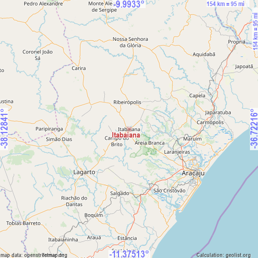
Itabaiana GPS coordinates[2]
10° 41' 6" South, 37° 25' 31.008" West
| Map corner | latitude | longitude |
|---|---|---|
| Upper-left | -9.9933°, | -38.12841° |
| Center: | -10.685°, | -37.42528° |
| Lower-right: | -11.37513°, | -36.72216° |
| Map W x H: | 153.6×153.6 km | = 95.4×95.4mi |
| max Lat: | 2.81972° ⇑34% North |
| Itabaiana: | -10.685° |
| min Lat: | ⇓66% South -33.69111° |
| min Long | Itabaiana | max Long |
| -72.89583° | -37.42528° | -32.41083° |
| W 87%⇐ | ⇒13% E |
Elevation
Elevation of Itabaiana is 190 m = 623 ft, and this is 190.9 m = 626 ft below average elevation for this country.
| Max E: |
1603 m = 5259 ft | 62.3% |
| Avg. | 380.9 m = 1250 ft | |
| Itabaiana | 190 m = 623 ft | |
Min E: |
0 m = 0 ft | 37.7% |
See also: Itabaiana elevation on elevation.city.
Geographical zone
Itabaiana is located in South Torrid zone (between Equator and Tropic of Capricorn). Distance of Equator is 1188.1 km =738.3 mi to North.| Distance of | km | miles | from Itabaiana |
|---|---|---|---|
| Equator | 1188.1 | 738.3 | to North |
| Tropic Capricorn | 1417.9 | 881 | to South |
| Antarctic Circle | 6213.1 | 3860.6 | to South |
| South Pole | 8819 | 5479.9 | to South |


Nearby cities:
15 places around Itabaiana: (largest is in red/bold)
• Areia Branca
14.5 km =9 mi,  123°
123°
• Campo do Brito
9.2 km =5.7 mi,  234°
234°
• Frei Paulo
19.2 km =11.9 mi,  321°
321°
• Lagarto
35.6 km =22.1 mi,  223°
223°
• Laranjeiras
31 km =19.3 mi, 115°
• Malhador
13.5 km =8.4 mi,  77°
77°
• Maruim
38 km =23.6 mi,  98°
98°
• Moita Bonita
15 km =9.3 mi,  37°
37°
• Nossa Senhora das Dores
33.2 km =20.6 mi,  49°
49°
• Nossa Senhora do Socorro
37.8 km =23.5 mi, 120°
• Ribeirópolis
16.2 km =10.1 mi,  3°
3°
• Salgado
39 km =24.2 mi,  188°
188°
• Santo Amaro das Brotas
42.1 km =26.2 mi,  105°
105°
• Simão Dias
42.6 km =26.5 mi,  261°
261°
• São Cristóvão
43.8 km =27.2 mi,  146°
146°
Sources, notices
• [Note1] Compared only with cities in Brazil existing in our database
• [Src1] Map data: © OpenStreetMap contributors (CC-BY-SA)
• [Src2] Other city data from geonames.org with taken over terms of usage.
• [Src3] Geographical zone / Annual Mean Temperature by Robert A. Rohde @ Wikipedia
