Macaé geodata
Macaé (Rio de Janeiro) is a populated place; located in Brazil in America/Sao_Paulo (GMT-3) time zone. With population of 143,029 people, there are 161 cities with bigger population in this country. Compared to other cities in Brazil, 72.4% of cities are located further ↑North; 66.8% of cities are located further ←West and 96.1% of cities have higher elevation than Macaé. Note1


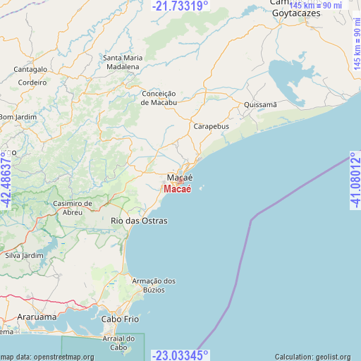
Macaé GPS coordinates[2]
22° 23' 5.424" South, 41° 46' 59.664" West
| Map corner | latitude | longitude |
|---|---|---|
| Upper-left | -21.73319°, | -42.48637° |
| Center: | -22.38484°, | -41.78324° |
| Lower-right: | -23.03345°, | -41.08012° |
| Map W x H: | 144.6×144.6 km | = 89.9×89.9mi |
| max Lat: | 2.81972° ⇑72.4% North |
| Macaé: | -22.38484° |
| min Lat: | ⇓27.6% South -33.69111° |
| min Long | Macaé | max Long |
| -72.89583° | -41.78324° | -32.41083° |
| W 66.8%⇐ | ⇒33.2% E |
Elevation
Elevation of Macaé is 8 m = 26 ft, and this is 372.9 m = 1223 ft below average elevation for this country.
| Max E: |
1603 m = 5259 ft | 96.1% |
| Avg. | 380.9 m = 1250 ft | |
| Macaé | 8 m = 26 ft | |
Min E: |
0 m = 0 ft | 3.9% |
See also: Macaé elevation on elevation.city.
Geographical zone
Macaé is located in South Torrid zone (between Equator and Tropic of Capricorn). Distance of this Southern Tropic circle is 117 km =72.7 mi to South.| Distance of | km | miles | from Macaé |
|---|---|---|---|
| Equator | 2489 | 1546.6 | to North |
| Tropic Capricorn | 117 | 72.7 | to South |
| Antarctic Circle | 4912.2 | 3052.3 | to South |
| South Pole | 7518.1 | 4671.5 | to South |


Nearby cities:
15 places around Macaé: (largest is in red/bold)
• Araruama
79 km =49.1 mi,  226°
226°
• Armação de Búzios
41.5 km =25.8 mi,  194°
194°
• Arraial do Cabo
69.3 km =43.1 mi,  201°
201°
• Cabo Frio
61.2 km =38 mi, 204°
• Campos dos Goytacazes
84.4 km =52.4 mi,  33°
33°
• Cantagalo
75.1 km =46.7 mi,  306°
306°
• Casimiro de Abreu
44.6 km =27.7 mi,  256°
256°
• Cordeiro
71.4 km =44.4 mi,  303°
303°
• Iguaba Grande
68.1 km =42.3 mi,  222°
222°
• Itaocara
85.1 km =52.9 mi,  339°
339°
• Nova Friburgo
77.8 km =48.3 mi,  278°
278°
• Rio das Ostras
22.9 km =14.2 mi, 226°
• Silva Jardim
69.1 km =42.9 mi,  244°
244°
• São Fidélis
82.2 km =51.1 mi,  2°
2°
• São Pedro da Aldeia
60.2 km =37.4 mi,  212°
212°
Sources, notices
• [Note1] Compared only with cities in Brazil existing in our database
• [Src1] Map data: © OpenStreetMap contributors (CC-BY-SA)
• [Src2] Other city data from geonames.org with taken over terms of usage.
• [Src3] Geographical zone / Annual Mean Temperature by Robert A. Rohde @ Wikipedia
