Itaocara geodata
Itaocara (Rio de Janeiro) is a populated place; located in Brazil in America/Sao_Paulo (GMT-3) time zone. With population of 16,762 people, there are 1106 cities with bigger population in this country. Compared to other cities in Brazil, 67.6% of cities are located further ↑North; 65.5% of cities are located further ←West and 72.4% of cities have higher elevation than Itaocara. Note1


Itaocara GPS coordinates[2]
21° 40' 9.012" South, 42° 4' 33.996" West
| Map corner | latitude | longitude |
|---|---|---|
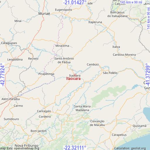
| Upper-left | -21.01427°, | -42.77924° |
| Center: | -21.66917°, | -42.07611° |
| Lower-right: | -22.32111°, | -41.37299° |
| Map W x H: | 145.3×145.3 km | = 90.3×90.3mi |
| max Lat: | 2.81972° ⇑67.6% North |
| Itaocara: | -21.66917° |
| min Lat: | ⇓32.4% South -33.69111° |
| min Long | Itaocara | max Long |
| -72.89583° | -42.07611° | -32.41083° |
| W 65.5%⇐ | ⇒34.5% E |
Elevation
Elevation of Itaocara is 99 m = 325 ft, and this is 281.9 m = 925 ft below average elevation for this country.
| Max E: |
1603 m = 5259 ft | 72.4% |
| Avg. | 380.9 m = 1250 ft | |
| Itaocara | 99 m = 325 ft | |
Min E: |
0 m = 0 ft | 27.6% |
See also: Brazil elevation on elevation.city.
Geographical zone
Itaocara is located in South Torrid zone (between Equator and Tropic of Capricorn). Distance of this Southern Tropic circle is 196.5 km =122.1 mi to South.| Distance of | km | miles | from Itaocara |
|---|---|---|---|
| Equator | 2409.4 | 1497.1 | to North |
| Tropic Capricorn | 196.5 | 122.1 | to South |
| Antarctic Circle | 4991.8 | 3101.8 | to South |
| South Pole | 7597.7 | 4721 | to South |


Nearby cities:
15 places around Itaocara: (largest is in red/bold)
• Além Paraíba
69.3 km =43.1 mi,  249°
249°
• Bom Jesus do Itabapoana
72.3 km =44.9 mi,  34°
34°
• Cambuci
20 km =12.4 mi,  58°
58°
• Cantagalo
45.9 km =28.5 mi,  220°
220°
• Carmo
62.3 km =38.7 mi,  241°
241°
• Cataguases
71.3 km =44.3 mi,  295°
295°
• Cordeiro
49.6 km =30.8 mi, 216°
• Itaperuna
55.2 km =34.3 mi,  20°
20°
• Leopoldina
60.6 km =37.7 mi,  284°
284°
• Miracema
31.2 km =19.4 mi,  336°
336°
• Muriaé
67 km =41.6 mi,  333°
333°
• Natividade
70.5 km =43.8 mi,  8°
8°
• Recreio
43.7 km =27.2 mi,  291°
291°
• Santo Antônio de Pádua
18 km =11.2 mi,  323°
323°
• São Fidélis
34.1 km =21.2 mi,  85°
85°
Sources, notices
• [Note1] Compared only with cities in Brazil existing in our database
• [Src1] Map data: © OpenStreetMap contributors (CC-BY-SA)
• [Src2] Other city data from geonames.org with taken over terms of usage.
• [Src3] Geographical zone / Annual Mean Temperature by Robert A. Rohde @ Wikipedia
