Leme geodata
Leme (São Paulo) is a populated place; located in Brazil in America/Sao_Paulo (GMT-3) time zone. With population of 81,209 people, there are 285 cities with bigger population in this country. Compared to other cities in Brazil, 71% of cities are located further ↑North; 60.7% of cities are located further →East and 75.3% of cities have lower elevation than Leme. Note1


Leme GPS coordinates[2]
22° 11' 8.016" South, 47° 23' 25.008" West
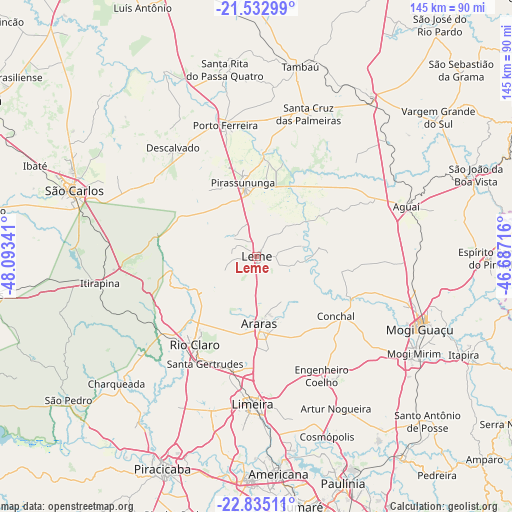
| Map corner | latitude | longitude |
|---|---|---|
| Upper-left | -21.53299°, | -48.09341° |
| Center: | -22.18556°, | -47.39028° |
| Lower-right: | -22.83511°, | -46.68716° |
| Map W x H: | 144.8×144.8 km | = 90×90mi |
| max Lat: | 2.81972° ⇑71% North |
| Leme: | -22.18556° |
| min Lat: | ⇓29% South -33.69111° |
| min Long | Leme | max Long |
| -72.89583° | -47.39028° | -32.41083° |
| W 39.3%⇐ | ⇒60.7% E |
Elevation
Elevation of Leme is 630 m = 2067 ft, and this is 249.1 m = 817 ft above average elevation for this country.
| Max E: |
1603 m = 5259 ft | 24.7% |
| Leme | 630 m 2067 ft | |
| Avg. | 380.9 m = 1250 ft | |
Min E: |
0 m = 0 ft | 75.3% |
See also: Leme elevation on elevation.city.
Geographical zone
Leme is located in South Torrid zone (between Equator and Tropic of Capricorn). Distance of this Southern Tropic circle is 139.1 km =86.4 mi to South.| Distance of | km | miles | from Leme |
|---|---|---|---|
| Equator | 2466.8 | 1532.8 | to North |
| Tropic Capricorn | 139.1 | 86.4 | to South |
| Antarctic Circle | 4934.4 | 3066.1 | to South |
| South Pole | 7540.3 | 4685.3 | to South |


Nearby cities:
15 places around Leme: (largest is in red/bold)
• Aguaí
44.7 km =27.8 mi,  71°
71°
• Araras
19.1 km =11.9 mi,  178°
178°
• Artur Nogueira
48.6 km =30.2 mi,  152°
152°
• Conchal
27.6 km =17.1 mi,  125°
125°
• Cordeirópolis
33.7 km =20.9 mi,  191°
191°
• Descalvado
39.2 km =24.4 mi,  322°
322°
• Iracemápolis
45.9 km =28.5 mi,  196°
196°
• Itirapina
45.1 km =28 mi,  260°
260°
• Limeira
42.2 km =26.2 mi, 181°
• Mogi Guaçu
50 km =31.1 mi,  113°
113°
• Pirassununga
21.4 km =13.3 mi,  350°
350°
• Porto Ferreira
38 km =23.6 mi, 346°
• Rio Claro
30.7 km =19.1 mi,  215°
215°
• Santa Cruz das Palmeiras
42.5 km =26.4 mi,  20°
20°
• Santa Gertrudes
33.4 km =20.8 mi,  205°
205°
Sources, notices
• [Note1] Compared only with cities in Brazil existing in our database
• [Src1] Map data: © OpenStreetMap contributors (CC-BY-SA)
• [Src2] Other city data from geonames.org with taken over terms of usage.
• [Src3] Geographical zone / Annual Mean Temperature by Robert A. Rohde @ Wikipedia
